O’Sullivan’s Island Fishing and Viewing Platform

O’Sullivan’s Island is a peninsula at the confluence of the Housatonic and Naugatuck Rivers under the Route 8 bridge that connects Derby and Shelton. NVCOG has assisted with several projects that make the site an asset for the region. 

Even with vehicles going over the peninsula on Route 8 and trains passing nearby, the site offers a peaceful spot for people to enjoy the riverfront. O’Sullivan’s Island is among the lower Naugatuck Valley’s most interesting and naturally beautiful land. It is also one of the most challenging brownfield locations NVCOG has had the opportunity to improve. 

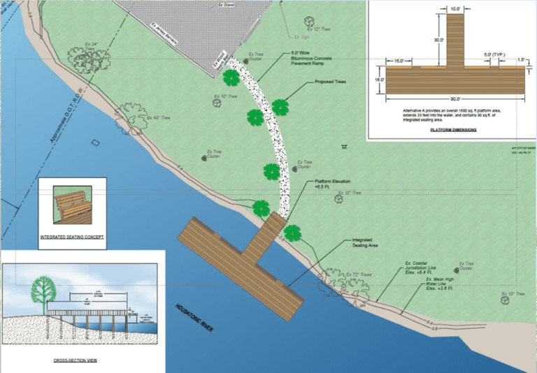
On July 13, 2023, NVCOG joined Derby Mayor Richard Dziekan; Rick Jacobson; Assistant Regional Director, U.S. Fish and Wildlife Service, and Deputy Commissioner Mason Trumble; Connecticut Department of Energy & Environmental Protection, to celebrate the opening of the handicapped-accessible fishing and viewing platform. The platform is 80 feet across, 16 feet wide, and will extend 30 feet into the river. The Pier will expand recreational opportunities along the river, supplemented by traffic from the nearby Naugatuck River Greenway Trail. 

Funding for the fishing pier was secured from several state and federal partners; including a $200,000 grant from the state Department of Economic and Community Development for site assessments and soil remediation; a $325,000 grant from the U.S. Fish and Wildlife Service, and an additional $204,252 from the state Department of Energy and Environmental Protection’s Federal Sport Fish Restoration program.

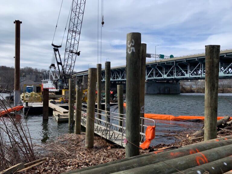
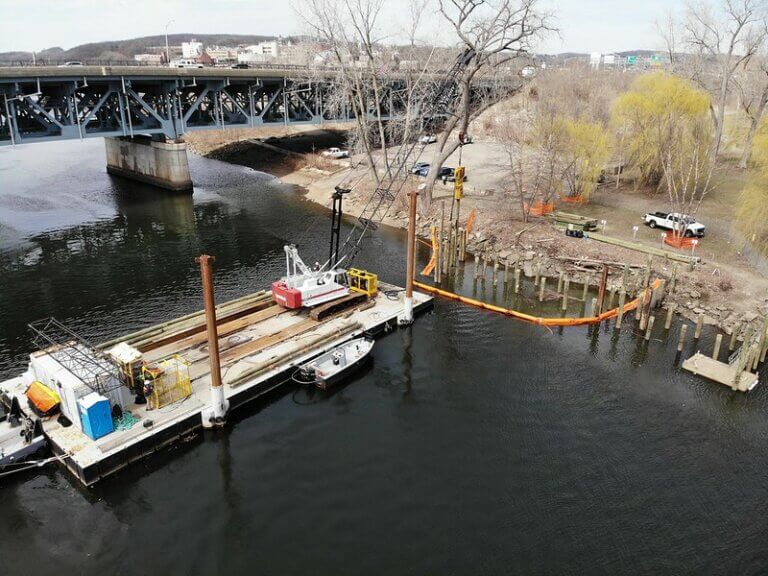
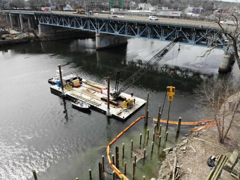
Progression of Construction

Work to make O’Sullivan’s Island started well before the fishing pier project. NVCOG Executive Director Rick Dunne, Environmental Planner Arthur Bogen, and Brownfields Manager Ricardo Rodriguez orchestrated funding and helped the City of Derby with work that transformed the site. That included getting a $200,000 grant from the Connecticut Department of Economic and Community Development for Phase I and Phase II Environmental Site Assessments. Those assessments are complete, and monitoring of the site is ongoing.

O’Sullivan’s Island Recreation Park reopened to the public in 2009 after being closed for over twenty years. In 2013, the City of Derby completed its portion of the Naugatuck River Greenway trail that runs across the site’s northern edge.

NVCOG managed grant funding, and HRP Associates completed the construction of the platform.

909 Bank Street, Waterbury

Project Type: (Completed) Environmental Site Assessment and Remediation

Activities: The Brooklyn neighborhood of  recently celebrated the opening of a new park. Click here to learn more. 

 The Naugatuck Valley Council of Governments conducted an environmental assessment in order to facilitate potential site transfer of the former vacant property. Assessment work was funded by EPA petroleum funds through NVCOG’s FY2016 EPA Assessment grant, as approved by the Connecticut Department of Energy and Environmental Protection and by U.S. EPA Region 1.

Upon completion of the assessment activities on site, the City of Waterbury was granted a $220,000 sub-awarded through NVCOG’s Revolving Loan Fund for remedial activities throughout the site. Remedial Activities were completed late 2020 with the Connecticut Department of Energy Environmental Protection providing a Voluntary Remediation Verification for the Site. The City of Waterbury has developed the site into a neighborhood “pocket” park. 

Project Status: Completed and open for use.

Regional Hazard Mitigation Plan Update

The final Regional Hazard Mitigation Plan and Municipal Annexes have been posted to the NVCOG Hazard Mitigation Plan webpageThe Plan has been adopted by all 19 NVCOG Communities, and the NVCOG Board endorsed the plan on December 10, 2021.  FEMA approved the plan in January, 2022.  

In 2019, NVCOG received funding from the Federal Emergency Management Agency (FEMA) to conduct a multi-jurisdictional Natural Hazard Mitigation Plan (NHMP) for all 19 NVCOG municipalities. 

An approved NHMP is required by FEMA to qualify a municipality for certain federal mitigation funding. NHMPs must be updated every 5 years. The purpose of this project is to update municipal NHMPs and develop a consolidated multijurisdictional plan for the entire Naugatuck Valley planning region in compliance with FEMA standards and requirements that will serve as the approved NHMP for each NVCOG municipality. 

Naugatuck River flooding in 1955

The NHMP will identify natural hazards and risks, existing capabilities, and activities that can be undertaken by a community to prevent loss of life and reduce property damages associated with the identified hazards. Public safety and property loss reduction are the driving forces behind this plan. Careful consideration will also be given to the preservation of history, culture and the natural environment of the region. 

Milone & MacBroom Inc. (MMI) was selected to serve as the project consultant. MMI has extensive experience developing NHMPs in the region and across the state.  NVCOG is administering the project and has prepared a detailed scope of work in collaboration with MMI. The project is expected to take 18 months and will include extensive public and stakeholder outreach and coordination with various municipal officials and departments.

Interactive Storymap:  

Click on the tabs at the top of the Project Storymap and scroll through the narrative to learn about hazards impacting the region and view topical maps.

Meetings and Workshops:

Public Information Meeting 8/4/2021
Recording
 
Public Workshop #2: Mitigation 
Recording
Slides
 
Coordinator Workshop #2: Mitigation
Recording
Slides
 
Public Workshop #1: Risk 
Slides
 
Coordinator Workshop #1: Risk
Recording 
Breakout Room Recording
Slides
 
Project Kickoff Meeting
Slides

Upcoming Meetings:

There are no upcoming events.

View Full Calendar

Staff Contact:  

Aaron Budris
Environmental Planning Director
abudris@nvcogct.gov

Waterbury West Main Street Corridor Study

West Main Street going east facing the Green

Final Report

A $23.1 million federal Rebuilding American Infrastructure with Sustainability and Equity (RAISE) grant the City of Waterbury received includes funding for long-overdue improvements that will revitalize West Main Street between the Waterbury Green and Riverside Drive, making it more comfortable for active transportation users, safer for drivers, and a more appealing urban street. 

The grant, awarded by the US Department of Transportation, will also extend the Naugatuck River Greenway from its current terminus at Eagle Street to West Main Street, providing for recreation and active transportation between the South End and Downtown.

The City is currently progressing design of West Main Street to meet the goals and objectives of the RAISE application and the West Main Study. The final report of the NVCOG West Main Street Study, linked below, will help to guide the project as it advances.  


Project Overview

Map of Project Area

West Main Street is a short but much-used corridor that connects downtown Waterbury with parts of the city that are on the west side of the Naugatuck River. But as important as it is, West Main Street also has issues that make using it a challenge for motorists, pedestrians, cyclists and transit users. The road surface is deteriorating, and the width varies significantly between two lanes in some areas to as much as six in others. For pedestrians, crossing West Main Street can be difficult. 

A complete streets approach has guided planning for upcoming work, which will include realigning intersections, narrowing parts of the road, rehabilitating existing sidewalks and building new ones, putting in bicycle lanes, and traffic calming strategies. Eyewitness News Channel 3 covered the story and interviewed NVCOG Director of Planning Josh Lecar.

Project Details

The biggest component of the project is reducing the number of travel lanes on West Main Street and making the road a uniform width. Plans call for eliminating an eastbound vehicle travel lane between Thomaston Avenue and the railroad overpass. More lane reductions are proposed in the eastbound direction east of Willow Street and Meadow Street. The number and width of vehicle travel lanes will also be reduced in the westbound direction between Willow Street and Meadow Street and Church Street. 

Reducing how much street space there is for motor vehicles would free up area along both sides of West Main Street for walkers, cyclists, and other users. New mid-block pedestrian crosswalks are planned, along with other enhancements that will make the road safer for walkers like high visibility treatments, pedestrian activated signal systems, and curb extensions are planned. For cyclists, dedicated bike lanes and a protected shared-used path are part of the plan. There also will be bus lanes, more on-street parking and traffic calming measures. 

Community Input

Community participation was a vital component to the study. Public meetings were held throughout the study and a public advisory committee was formed to help the planners. The PAC met for the third and final time on Sept. 28, 2021, and heard a presentation on the project from Fuss & O’Neill, the firm that helped NVCOG and the city with the study. 

Staff Contact: 

Rich Donovan
Transportation Planning Director
rdonovan@nvcogct.gov

Route 229 Corridor Study

Final Public Meeting: May 26, 2022

The final public engagement meeting occurred on Thursday, May 26th, with both a virtual option and an in person meeting at the Bristol Public Library. The study team started by presenting recommendations for improvements along the corridor, followed by an opportunity for public comment on those changes. The meeting recording is available on the NVCOG YouTube page and is linked below. Comments will be accepted in writing to contactus@nvcogct.gov through June 27, 2022, and will be incorporated in the final report. 

Meeting Recording

Draft Final Report 

Second Public Meeting: September 29, 2021

A second public engagement session was held on Wednesday, September 29. It began with a guided tour of the corridor, including stops in both Bristol and Southington. More details of the locations visited are in the flyer below. This was followed by a public meeting at the Bristol Library. For those who were unable to attend the meeting there is a recording available on the NVCOG YouTube page that is linked below. Slides from this meeting have also been posted. 

Tour Flyer

See a recording of the meeting here: https://www.youtube.com/watch?v=77q3zOrCYm8

Slides for this meeting can be found here

First Public Meeting: April 14, 2021

The Route 229 project team held a virtual public meeting on April 14 between 5 – 7 pm. The goals and objectives of the Route 229 Corridor study were discussed and stakeholders had the opportunity to ask questions and offer public input on this project. 

See a Recording of the meeting here: https://youtu.be/2f0RTZFTNQo

Slides for this meeting are available here

Waterbury Area Transit Study (WATS)

The Waterbury Area Transit Study (WATS) was completed in December 2017. WATS was a comprehensive review of the CTtransit Waterbury system, aimed at improving service, enhancing the rider experience, and identifying gaps in the current routing. Study documents, attached below, remain an important tool in NVCOG’s ongoing advocacy for bus transit improvements within the Waterbury Area. 

View study documents below:

Market Analysis

Recommendations

Staff Contact

Joanna Rogalski
Senior Regional Planner
jrogalski@nvcogct.gov

Regional Wastewater Treatment Consolidation Study

Wastewater equipment in Seymour.

Wastewater equipment in Seymour.
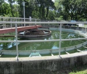
The state Office of Policy and Management (OPM) has authorized $1.35 million for NVCOG to conduct a regional wastewater treatment consolidation study. The study, which began in April 2018,  will provide a preliminary analysis to help determine the region’s ability to increase capacity for properly treating wastewater in a consolidated facility or facilities, thereby leading to a reduction in long-term state and local capital improvements and a reduction of user fees.

Specifically, wastewater treatment plants in the municipalities of Naugatuck, Beacon Falls, Seymour, Ansonia and Derby are being analyzed for potential consolidation and/or the sharing of services. In addition to providing potential recommendations to mitigate costs and capital expenditures that will be required for upgrades to the wastewater treatment plants located in these communities, the study is designed to set an example for other communities throughout Connecticut in consolidating plants and reducing costs. The NVCOG conducted a Request for Proposal for study consultant services in mid-2017. Following a Qualification Based Selection process, Black & Veatch, of Overland Park, Kansas, was selected as the vendor. 

The study is being conducted in two phases. Phase 1 concluded in early 2019. The tasks included a review of existing planning documents and related assessments of existing wastewater treatment facilities and collection system infrastructures. It also provided an estimation of 20-year wastewater flows and load projections for each participating municipality, summarized existing wastewater system management and governance for each participating municipality, and identified potential opportunities for cost savings and operational efficiencies through alternative approaches to system management and governance structure. In addition, Phase 1  identified a long list of wastewater regionalization alternatives that appear to have initial merit for consideration.

Phase 2, which began in March 2020, will include a more extensive technical and engineering analysis, as well as identification of a short list of alternatives and preferred alternative(s) to the systems currently in place. It will also include a Cost Benefit Analysis, crafting of a Governance Model for any proposed regional wastewater entity and Environmental Impact Evaluation (EIE). It is expected to formally conclude in early 2022.

Share this page

Ansonia-Derby Regional School Study

Old classroom in a museum


Ansonia-Derby School Regionalization Study

In May 2018, The Connecticut General Assembly approved Public Act 18-169, which appropriated funding for a school consolidation study for the Cities of Ansonia and Derby. In accordance with Connecticut State Statutes §10-39 through §10-43, the cities’ Boards of Aldermen subsequently appointed members of the Temporary Regional School Study Committee (TRSSC).

NVCOG’s function in the study was to serve as fiduciary and contracting authority. Following a Qualification Based Selection process for a study consultant, District Management Group, of Boston, MA, was selected as consultant.

The study analyzed a number of areas regarding the advisability of combining school districts. It also analyzed potential cost savings or operational efficiencies resulting from shared services in separate school districts. The TRSSC expired according to state statute in February 2022 and members chose not to issue a recommendation. 

Consultant Documents:

Staff Contact:

Rick Dunne
Executive Director
rdunne@nvcogct.gov

Share this page

Naugatuck 251 Rubber Ave

NAUG 251RubberAve

Project Type: Assessment 

Activities: Phase I and Phase II Environmental Site Assessments

NVCOG has conducted an environmental assessment in order to facilitate potential site transfer. The property is improved by a 2-bay service garage. Assessment is funded by petroleum funds through NVCOG’s FY2016 EPA Assessment grant, as approved by the Connecticut Department of Energy and Environmental Protection and by U.S. EPA Region 1.


Project Status: Phase I and Phase II Environmental Site Assessments complete.