The Metropolitan Area Planning Forum, commonly referred to as the MAP Forum, is a consortium of metropolitan planning organizations (MPOs) and councils of government in New York, New Jersey, Connecticut and Pennsylvania that have voluntarily agreed to coordinate and collaborate on transportation planning activities in the multi-state metropolitan area. The MAP Forum was established in 2008 with a focus on the New York metropolitan area, but the consortium has expanded over the years to encompass the four-state area and added members in Connecticut, New York and Pennsylvania.
Click here to visit the MAP Forum’s website.
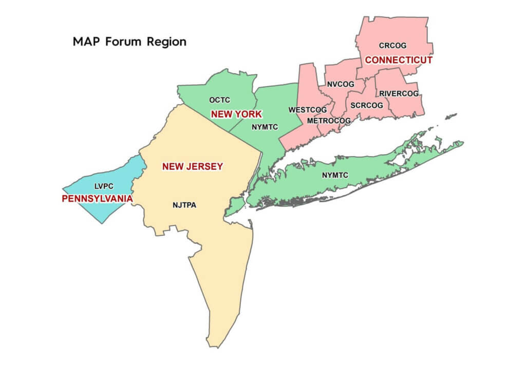
Members are:
- New York Metropolitan Transportation Council (NYMTC)
- Orange County (New York) Transportation Council (OCTC)
- North Jersey Transportation Planning Authority (NJTPA)
- Western Connecticut Council of Governments (WestCOG)
- Connecticut Metro Council of Governments (METROCOG)
- Naugatuck Valley Council of Governments (NVCOG)
- South Central Regional Council of Governments (SCRCOG)
- Lower Connecticut River Valley Council of Governments (RiverCOG)
- Capitol Region Council of Governments (CRCOG)
- Lehigh Valley (Pennsylvania) Planning Commission (LVPC)
The MAP Forum provides organizational and strategic guidance to member MPOs in planning for and understanding megaregional and boundary transportation projects. Because of the size, complexities and interdependence of the New York-New Jersey-Connecticut-Pennsylvania area, a major transportation investment in one part of the area can and will have implications throughout the region. It is imperative to be properly informed about these projects and fully understand how they will affect travel into, out of, and through the component metropolitan planning areas. The networking capabilities of the MAP Forum as it relates to federally-mandated products and analyses is a critical function of the group. While the exchange of planning products is a key aspect of the MAP Forum’s work program, it is the access to expertise and resources of member organizations that provides the greatest benefits.
Key accomplishments of the MAP Forum are:
- Meets two times each year. Agendas focus on critical megaregional and boundary programs and projects.
- Holds periodic organizational conference calls to discuss and coordinate planning issues.
- Developed a work program that centers on maintaining the critical networking capability of the MAP Forum.
- Established a Multi-State Freight Working Group to provide a broad perspective on goods movement in the multi-state metropolitan region and advise the MAP Forum members on critical freight issues, programs and projects impacting the multi-state metropolitan region.
- Coordinated on the development of a Congestion Management Process for the NY metro area and collaborated on setting transportation Performance Measures.
- Initiated development of an online platform for exchanging program documents, discussing opportunities for collaborative activities and engaging consultation on transportation modeling, agency work programs, transportation improvement programs (TIPs), and metropolitan transportation plans.
Transportation Systems
The transportation system of the four-state metropolitan region is large and complex, tied together by a network of highways, rail lines, bridges, tunnels, and other infrastructure.
Interstate Highways:
- I-78, I-80 and I-280 – extend from New York City west into Pennsylvania
- I-87 – extends north from New York City and becomes the New York Thruway
- I-95 – traverses the area and provides access to New England
- New Jersey Turnpike – overlaps I-95 from New York City
- I-495 – extends from New York City through Long Island; also known as the Long Island Expressway
Commuter Rail Lines:
- New Jersey Transit – multiple heavy rail lines, many operating from Penn Station in New York City
- MTA Metro-North Railroad – two lines serving north New Jersey (Port Jervis and Pascack Valley lines), two lines serving the New York Hudson Valley region (Harlem and Hudson lines) and the New Haven main line and three branch lines serving Connecticut
- MTA Long Island Rail Road – serving Long Island
- Shore Line East (Connecticut)
- Hartford Rail Line – New Haven (CT) and Hartford (CT) to Springfield (MA)
Rapid Rail Transit Systems:
- MTA New York City Transit’s subway network
- Port Authority of New York & New Jersey’s PATH rail rapid transit service
- New Jersey Transit’s Hudson-Bergen Light Rail and Newark Light Rail systems
Intercity Rail:
- Amtrak along the North East Corridor from Washington, DC to Boston.
Maritime:
- Freight facilities at the Port of New York & New Jersey and reliever ports in Bridgeport, New Haven and New London.
Major Commercial Airports:
- John F. Kennedy International Airport (JFK) in southern Queens
- Newark Liberty International Airport (EWR) in Newark
- LaGuardia Airport (LGA) in northern Queens
Major Bridges and Tunnels:
- George Washington Bridge (Hudson River)
- Tappan Zee Bridge (Hudson River)
- Whitestone Bridge (East River)
- Troggs Neck Bridge (East River/Long Island Sound)
- Goethals Bridge (Arthur Kill Strait)
- Verrazzono-Narrows Bridge
- Lincoln Tunnel (Hudson River)
- Holland Tunnel (Hudson River)