359 Mill Street, Waterbury (Brass City Harvest)


Project Type: Cleanup Planning

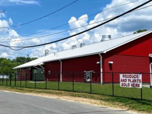
Activities: The Revolving Loan Fund Committee of NVCOG has awarded the Waterbury Development Corporation a $86,000 sub-grant to assist with State remedial closeout requirements at 359 Mill Street, Waterbury. The Site, also known as the Brass City Harvest, is a 501(c)(3) non-profit organization that uses urban agriculture to build self-reliance skills, empower residents to modify their dietary behaviors, and increase fresh food access points in the community. This food hub now infuses more than 200,000 pounds of fresh, locally grown food into the community each year. 


Recently, NVCOG granted a supplemental award of $285,000 to conduct cleanup planning at two adjacent, vacant parcels at Lot #19 and 777 South Main Street. Once remediated, these parcels will house an expanded marketplace and new greenhouses. Environmental requirements include groundwater sampling and monitoring, as well as closeout reports.


Project Status: The Waterbury Development Corporation has secured the environmental firm to complete Phase II of the

project, including remedial design and soil and groundwater remediation on Lot #19 and 777 South Main Street. Phase I of remedial activities have been completed. Phase II will begin in late summer 2023.

313 Mill Street, Waterbury


Project Type: Cleanup Planning

Activities: A baseball field and community park now stand on the remnants of a former industrial parcel in Waterbury’s south end. In 2012, the former Nova Dye factory burned, leaving a contaminated and vacant parcel in one of the city’s most underserved areas. The project was facilitated by a $200,000 award from NVCOG’s Revolving Loan Fund meant to close environmental data gaps and an additional $3,000,000 provided by the state. The park, adjacent to the Mad River, now provides a safe space for recreational opportunities in a neighborhood that previously had little access to green space. 

Project Status: Remediation and construction work is complete. The park is open to the public.

Mad River, Waterbury

River and Building

River and Building

Project Type: Cleanup

NVCOG oversaw a $500,000 grant for assessment and remediation across multiple parcels on behalf of the Waterbury Development Corporation (WDC). The remaining funds were allocated to conduct clean-up activities at Lot 19, where Brass City Harvest has constructed a regional food hub for cleaning and preparing locally-grown foods for distribution.

Project Status: Remediation activities have been completed.

130 Freight Street, Waterbury

Project Type: Cleanup Planning

Assessment Activities: NVCOG’s Revolving Loan Fund Committee awarded the Waterbury Development Corporation a $200,000 sub-grant for cleanup planning activities at 130 Freight Street Waterbury. Funds at the former Anaconda American Brass factory will be applied for assessment, cleanup planning, and environmental professional services on site. The site is included in the City of Waterbury’s Master Plan for the Freight Street District, in which mixed-rate residential units, commercial space and industrial space. A portion of the site will be maintained as green space. Environmental activities have commenced on site. The City has secured additional funding for demolishing the neighboring building, which will be considered a separate project.

909 Bank Street, Waterbury

Project Type: (Completed) Environmental Site Assessment and Remediation

Activities: The Brooklyn neighborhood of  recently celebrated the opening of a new park. Click here to learn more. 

 The Naugatuck Valley Council of Governments conducted an environmental assessment in order to facilitate potential site transfer of the former vacant property. Assessment work was funded by EPA petroleum funds through NVCOG’s FY2016 EPA Assessment grant, as approved by the Connecticut Department of Energy and Environmental Protection and by U.S. EPA Region 1.

Upon completion of the assessment activities on site, the City of Waterbury was granted a $220,000 sub-awarded through NVCOG’s Revolving Loan Fund for remedial activities throughout the site. Remedial Activities were completed late 2020 with the Connecticut Department of Energy Environmental Protection providing a Voluntary Remediation Verification for the Site. The City of Waterbury has developed the site into a neighborhood “pocket” park. 

Project Status: Completed and open for use.

MTP 2050

NVision50: The Metropolitan Transportation Plan for the NVCOG and the Central Naugatuck Valley MPO lays out a comprehensive vision for transportation in our region leading up to 2050.

Interstate 84/ Route 8 New Mix

The Mixmaster

The interchange of Interstate 84 and Connecticut Route 8, located just west of Downtown Waterbury, has long been called “the Mixmaster” because of the complex web of highways, ramps, local roads, and rail, that make it up or pass below. Originally hailed as a marvel of modern highway design, the Mixmaster no longer meets highway design standards, is often crowded, and has left a significant mark on the City. The Mixmaster is currently undergoing work to extend its life for an estimated 25 years, after which a more permanent solution will be required.  

The NewMix

While the Mixmaster undergoes efforts to extend its life and improve safety and traffic flow, the CTDOT, with the assistance of HNTB Corporation, have begun planning the long-term future for the interchange. The NVCOG, the City of Waterbury, and other interested parties regularly attend Project Advisory Committee meetings. The project team has also held several public information session, the most recent of which was on September 15th, 2022. Recordings and presentation material from all of these meetings, as well as other information about the project, can be found on the CTDOT’s project website, linked here: https://www.newmixwaterbury.com.

This website includes a spot where anyone can leave a comment or ask a question. The CTDOT’s NewMix project team is dedicated to ensuring this process actively engages the public, so all comments are encouraged. Comments or questions can be submitted here.

Presentation to Local Leaders

On June 30, 2021, the NewMix Project Team presented the plan for the NewMix study to local elected officials. The content of this presentation is available below. 

View The New Mix PowerPoint presentation or watch a recording of this presentation on the NVCOG YouTube Channel.

Staff Contact

Mark Nielsen
NVCOG Assistant Director
mnielsen@nvcogct.gov

Kinneytown Dam Removal

For nearly two centuries, migratory fish have been blocked from most of the Naugatuck River by Kinneytown Dam in Seymour.  That continues today, with the facility no longer producing electricity and serving no useful purpose.  Now, a project is underway led by NVCOG in partnership with Save the Sound to remove Kinneytown Dam.  Removal will open miles of restored habitat to shad, alewife, lamprey, river herring and other anadromous fish, and will also reduce flood risk, remove a safety concern and eyesore, and reconnect communities to recreational opportunities along the Naugatuck River.    

Kinneytown Dam and Fish Ladder
Kinneytown Dam and Fish Ladder, Seymour, CT

After the longstanding failure of a fish ladder at Kinneytown Dam came to light in 2019, the Naugatuck River Restoration Coalition was formed to advocate for the restoration of fish passage on the Naugatuck River. Consisting of NVCOG, the Naugatuck River Revival Group, and Save the Sound, the Coalition has worked with state and federal regulatory agencies to shed light on the failure to pass fish as required by Kinneytown Dam’s federal license exemption and encouraging the dam owner to remedy the situation.    

It has become clear that restoring hydroelectric generation while providing safe, timely and effective fish passage at Kinneytown Dam is not economical, and removal of the dam is the only way to fully restore fish passage at the site.   In partnership with Save the Sound, NVCOG applied for and received funding through the NOAA Restoring Fish Passage Through Barrier Removal grant program under the Bipartisan Infrastructure Law (BIL) in 2022 for the acquisition and decommissioning of the facility, and for the design and construction work leading to the dam’s removal.  The project is supported by municipal leaders, state and federal regulatory agencies, the CT federal delegation, environmental advocates, and the current dam owner.   

The Coalition has developed an Interactive Story Map to explain the issue. Project details will be continually added here and on the Story Map, so please check back often!

Explore the Issue:

This interactive storymap details the effort to restore migratory fish to the Naugatuck River, the longstanding issues at Kinneytown, and the current plan to remove the dam. 

NVCOG FERC Docket Filings:

You can find a full annotated timeline of FERC docket P-6985 filings HERE

Staff Contact:

Aaron Budris
Environmental Planning Director
abudris@nvcogct.gov

Regional Hazard Mitigation Plan Update

The final Regional Hazard Mitigation Plan and Municipal Annexes have been posted to the NVCOG Hazard Mitigation Plan webpageThe Plan has been adopted by all 19 NVCOG Communities, and the NVCOG Board endorsed the plan on December 10, 2021.  FEMA approved the plan in January, 2022.  

In 2019, NVCOG received funding from the Federal Emergency Management Agency (FEMA) to conduct a multi-jurisdictional Natural Hazard Mitigation Plan (NHMP) for all 19 NVCOG municipalities. 

An approved NHMP is required by FEMA to qualify a municipality for certain federal mitigation funding. NHMPs must be updated every 5 years. The purpose of this project is to update municipal NHMPs and develop a consolidated multijurisdictional plan for the entire Naugatuck Valley planning region in compliance with FEMA standards and requirements that will serve as the approved NHMP for each NVCOG municipality. 

Naugatuck River flooding in 1955

The NHMP will identify natural hazards and risks, existing capabilities, and activities that can be undertaken by a community to prevent loss of life and reduce property damages associated with the identified hazards. Public safety and property loss reduction are the driving forces behind this plan. Careful consideration will also be given to the preservation of history, culture and the natural environment of the region. 

Milone & MacBroom Inc. (MMI) was selected to serve as the project consultant. MMI has extensive experience developing NHMPs in the region and across the state.  NVCOG is administering the project and has prepared a detailed scope of work in collaboration with MMI. The project is expected to take 18 months and will include extensive public and stakeholder outreach and coordination with various municipal officials and departments.

Interactive Storymap:  

Click on the tabs at the top of the Project Storymap and scroll through the narrative to learn about hazards impacting the region and view topical maps.

Meetings and Workshops:

Public Information Meeting 8/4/2021
Recording
 
Public Workshop #2: Mitigation 
Recording
Slides
 
Coordinator Workshop #2: Mitigation
Recording
Slides
 
Public Workshop #1: Risk 
Slides
 
Coordinator Workshop #1: Risk
Recording 
Breakout Room Recording
Slides
 
Project Kickoff Meeting
Slides

Upcoming Meetings:

There are no upcoming events.

View Full Calendar

Staff Contact:  

Aaron Budris
Environmental Planning Director
abudris@nvcogct.gov

Waterbury West Main Street Corridor Study

West Main Street going east facing the Green

Final Report

A $23.1 million federal Rebuilding American Infrastructure with Sustainability and Equity (RAISE) grant the City of Waterbury received includes funding for long-overdue improvements that will revitalize West Main Street between the Waterbury Green and Riverside Drive, making it more comfortable for active transportation users, safer for drivers, and a more appealing urban street. 

The grant, awarded by the US Department of Transportation, will also extend the Naugatuck River Greenway from its current terminus at Eagle Street to West Main Street, providing for recreation and active transportation between the South End and Downtown.

The City is currently progressing design of West Main Street to meet the goals and objectives of the RAISE application and the West Main Study. The final report of the NVCOG West Main Street Study, linked below, will help to guide the project as it advances.  


Project Overview

Map of Project Area

West Main Street is a short but much-used corridor that connects downtown Waterbury with parts of the city that are on the west side of the Naugatuck River. But as important as it is, West Main Street also has issues that make using it a challenge for motorists, pedestrians, cyclists and transit users. The road surface is deteriorating, and the width varies significantly between two lanes in some areas to as much as six in others. For pedestrians, crossing West Main Street can be difficult. 

A complete streets approach has guided planning for upcoming work, which will include realigning intersections, narrowing parts of the road, rehabilitating existing sidewalks and building new ones, putting in bicycle lanes, and traffic calming strategies. Eyewitness News Channel 3 covered the story and interviewed NVCOG Director of Planning Josh Lecar.

Project Details

The biggest component of the project is reducing the number of travel lanes on West Main Street and making the road a uniform width. Plans call for eliminating an eastbound vehicle travel lane between Thomaston Avenue and the railroad overpass. More lane reductions are proposed in the eastbound direction east of Willow Street and Meadow Street. The number and width of vehicle travel lanes will also be reduced in the westbound direction between Willow Street and Meadow Street and Church Street. 

Reducing how much street space there is for motor vehicles would free up area along both sides of West Main Street for walkers, cyclists, and other users. New mid-block pedestrian crosswalks are planned, along with other enhancements that will make the road safer for walkers like high visibility treatments, pedestrian activated signal systems, and curb extensions are planned. For cyclists, dedicated bike lanes and a protected shared-used path are part of the plan. There also will be bus lanes, more on-street parking and traffic calming measures. 

Community Input

Community participation was a vital component to the study. Public meetings were held throughout the study and a public advisory committee was formed to help the planners. The PAC met for the third and final time on Sept. 28, 2021, and heard a presentation on the project from Fuss & O’Neill, the firm that helped NVCOG and the city with the study. 

Staff Contact: 

Rich Donovan
Transportation Planning Director
rdonovan@nvcogct.gov