Farm Fresh

Whether you are looking for apple picking, Christmas tree farms, or a local CSA, we have it mapped for the Naugatuck Valley region.  Please use this resource to find farm-fresh fruits and vegetables and to support the region’s agricultural economy.

Screenshot of Agriculture Map


Types of activities showcased are farmer’s markets, community-supported agriculture (CSA), farms with pick-your-own fruits and vegetables, farms with cut-your-own Christmas trees, wineries and vineyards, animal farms open to the public, and country fairs in the nineteen municipalities of the Naugatuck Valley region.  Data is sourced from the State of Connecticut.

To submit a new activity or farm, please email us.

Bringing Awareness of the 2020 Census with a Valley-wide Complete Count Committee

US Census 2020 logo

Group of leaders at Valley Complete Count Committee kickoff

Civic leaders and non-profits are joining together to vocalize the importance of the upcoming 2020 Census to the residents of the Naugatuck Valley. Connecticut Lt. Governor Susan Bysiewicz helped launch the Naugatuck Valley Complete Count Committee, stating an accurate count is critically important to Connecticut as it is the foundation to determine federal funding allocations to the state.  This includes funding for transportation projects, education, low-income programs, and other public services.  Derby Mayor Richard Dziekan emphasized how some areas of the Naugatuck Valley are hard to count and it’s essential to get the word out that the Census is safe, easy, and important.  Expect to see representatives from the U.S. Census Bureau at local events in Beacon Falls, according to First Selectman Christopher Bielik.  He brought up how important participation in the Census is, as Connecticut saw after the 2000 Census by losing one congressional representation seat because of a lower population count.

This is the first Census count available via phone and internet. The U.S. Census Bureau is also hiring local temporary workers.

For more information on all things 2020 Census in our region, visit our webpage, or Census.gov.

Derby Mayor Richard Dziekan speaking at the kickoff event
Derby Mayor Richard Dziekan speaking at the kickoff event.
First Selectman Christopher Bielik speaking at the kickoff event.

Route 8 Northbound Lane Closures & Temporary Bypass Opening

Road work ahead sign

Copied from Mixmaster Rehabilitation

The Connecticut Department of Transportation is announcing that in order to complete construction work associated with the Route 8/I-84 Interchange (Mixmaster) rehabilitation project in Waterbury will close one lane on Route 8 Northbound. This closure will take place on Friday, August 23, 2019 beginning at 9:00 a.m.   The project consists of the rehabilitation of numerous bridges located within the Route 8 and I-84 Interchange and was awarded to Walsh Construction Company at a cost of $152,960,945.27 on April 18, 2018 and is scheduled to be completed September 10, 2022.  This project is administered by the Office of Construction – District 4, Thomaston.

Closure and Temporary Bypass Information

One lane on Route 8 Northbound will be closed on Friday, August 23, 2019 beginning at 9:00 a.m. This paving will continue around-the-clock in order to complete paving to connect the Southeast and Northeast approaches of the Temporary Bypass to existing Route 8.

One lane of the temporary bypass will open on Friday, August 23, 2019 and an additional lane will open on Sunday, August 25, 2019.

Motorists looking to access I-84 Westbound should continue on the existing Route 8. Motorists looking to access I-84 Eastbound will utilize the temporary bypass, continue to Exit 35 and use the Median U-Turn back onto Route 8 Southbound to access I-84 Eastbound. Motorists traveling to Torrington and points north should utilize the Temporary Bypass and then continue on to existing Route 8 Northbound.

Temporary and permanent signage will be in place to direct motorists to their destination. Motorists are advised to not drive distracted and follow speed limits.     Route 8 and Interstate 84 detour map


Visit Mixmaster Rehabilitation to find more information about the project and to sign-up to receive updates from CTDOT about the project

Take a hike!

Explore the recreational trail network that is in or passes through the Naugatuck Valley region. Types of trails include walking trails or paths, hiking trails, nature trails, and multi-use (any combination of walking, biking, rollerblading, cross-country skiing, or horseback riding) trails.

Visit our Regional Trails interactive map.

Active Valley CT

Active Valley CT

NVCOG has been working with the Yale-Griffin Prevention Center at Griffin Hospital in creating Active Valley CT, a free public resource for the residents of the Lower Naugatuck Valley to find no-cost and low-cost locations to be physically active. PRC recommends adults to get at least 2.5 hours of physical activity each week and even more hours for children. Use this resource to search for swimming locations, ball fields, playgrounds, and more.
Flyer for Active Valley CT

Public Meetings for the NRG Torrington to Thomaston Routing Study

Press Release

Contacts:
Aaron Budris

Naugatuck Valley Council of Governments

203-757-0535

abudris@nvcogct.org

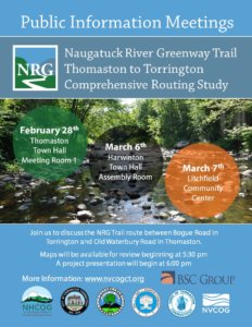
Upcoming Meetings will Provide Opportunities for Public Input on Naugatuck River Greenway Trail Route

Harwinton, Litchfield, Thomaston and Torrington residents can review and provide feedback on prospective locations and plans for the Naugatuck River Greenway Trail during a series of upcoming public meetings. Project partners and community leaders will be on hand for the meetings, which will be held on February 28th at Thomaston Town Hall, March 6th at the Harwinton Town Hall, and March 7th at the Litchfield Community Center. All meetings will begin at 5:30 with an informal opportunity to view maps and talk to project staff. A formal presentation will begin at 6:00 pm and will be followed by a question and answer period and a review of specific comments with residents.

The public outreach follows more than one year of studying potential Naugatuck River Greenway Trail routing options between Torrington and Thomaston. The purpose of the NRG Torrington to Thomaston Comprehensive Routing Study, being conducted by BSC Group of Glastonbury, CT is to inventory potential routes and rank them with stakeholder and public input with the goal of selecting a final preferred route with broad consensus. BSC will also provide phasing recommendations and preliminary construction cost estimates of the preferred route to help municipalities plan for future construction and prepare for potential funding opportunities.

The Naugatuck Valley Council of Governments (NVCOG), in partnership with the Northwest Hills Council of Governments (NHCOG), received a Transit Oriented Development and Smart Growth grant from the Connecticut Office of Policy and Management (OPM) to conduct the study. The NVCOG and NHCOG are overseeing the project.

The project area spans approximately 11 miles of the Naugatuck Valley from Bogue Road in Torrington to a section of trail under design adjacent to the Water Pollution Control facility on Old Waterbury Road in Thomaston. During the past year, BSC and project partners inventoried all potential trail routes along with points of interest and environmental constraints along the way, and documented property ownership and stakeholder preferences and concerns. This information has been used to narrow down prospective routes to those that are most feasible. Now, public input is being solicited to help determine what route should ultimately be built when funding is secured.

Stakeholders have been involved throughout the project including chief elected officials and staff from the municipalities of Torrington, Litchfield, Harwinton and Thomaston along with representatives from the US Army Corps of Engineers, NVCOG, NHCOG, the Naugatuck River Greenway Steering Committee, The Railroad Museum of New England, and several property owners along the route.

The NRG corridor has been officially designated as a greenway by the CT Greenways Council and the CT Department of Energy and Environmental Protection (DEEP). The entire greenway trail is identified as a trail of statewide significance in the Connecticut Recreational Trails Plan, and was designated as one of 101 America’s Great Outdoors projects in 2011 by the U. S. Department of the Interior. An Economic Impact Study conducted by NVCOG in 2017 estimated that there would be substantial economic, health and community benefits of constructing the trail.

The overall planned NRG trail route will follow the river for 44 miles, bringing it through parts of Torrington, Litchfield, Harwinton, Thomaston, Watertown, Waterbury, Naugatuck, Beacon Falls, Seymour, Ansonia and Derby. To date, trail sections have been constructed in Torrington, Watertown, Naugatuck, Beacon Falls, Seymour, Ansonia and Derby. “We really want to hear what the public envisions for the NRG Trail,” said Bill Paille, Transportation Engineer at BSC Group. “We want to be sure that the preferred route meets each community’s long term needs and that the investments made are well-spent and provide the most benefit to residents.”

More information can be found on the study’s webpage.

Follow NVCOG on Twitter!

The Naugatuck Valley Council of Governments is officially on Twitter! Please follow our organization to find out the latest news. We’re excited to increase our presence on social media and hope this will result in further engagement with residents, businesses, and stakeholders.