Route 67 Enhancements
Design & Construction
Martha Street will be closed to traffic and inaccessible from Bank Street starting on March 13, 2024. Vehicles exiting 100 Bank Street will have to follow the detour signs.
The design work was completed in September 2023 and the project will proceed to construction in the Spring of 2024.
The project went out to bid for construction. The lowest bidder is Guerrera Construction Co., and their bid price is $5,854,159.00. The CTDOT is handling the bid and award contract.
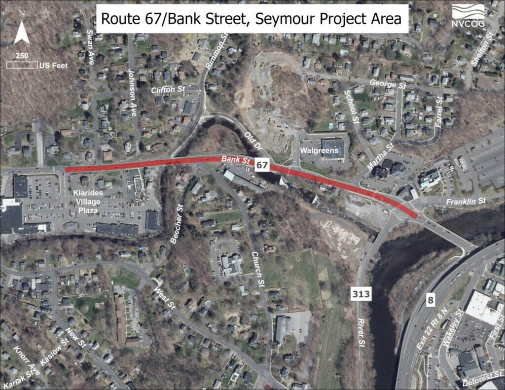
Take a Look
Click on the links below to access detailed design plan documents.
- Final Design Plans
- Simplified view of the plan
- Final Design Report
Anticipated Improvements
The following improvements are anticipated:
1. Klarides Village and Bank Street (unsignalized)
– Construct a new raised island within the existing driveway to physically restrict and reinforce the left-turn prohibition for vehicles exiting the development and to revise the pavement markings on Bank Street to provide the required width for Route 67 westbound traffic to bypass vehicles turning left into the development.
2. Bank Street at Church Street/Beecher Street (unsignalized)
– Reconstruct and realign Church Street to create a T-intersection with Beecher Street separated from the intersection with Bank Street and provide a right-turn lane for northbound vehicles at Bank Street.
3. Route 67 (Bank Street) from Old Drive to Franklin Street/River Street (SR 313)
– Extend the westbound right-turn lane to Old Drive East between Old Drive East and the Walgreens Plaza driveway.
– Extend dual westbound through lanes from Franklin Street to Martha Street to lengthen the vehicle merge distance.
– Widen Route 67 to provide adequate turn-lane lengths and 5′ shoulders on both the north and south sides of the road and reconstruct sidewalks.
– Replace traffic signal equipment at the Franklin Street/River Street intersection, improve traffic signal operations and efficiency, and adjust signal timings within the project limits.
– Improve intersection geometrics, pedestrian accommodations, and accessible crosswalks.
Breakout Project
River Street
This project is a separate undertaking with its own distinct timeline. It has been separated to avoid delays for the rest of the improvements, as it requires additional time for planning and details. Further information on this project will follow.
The goal is to widen River Street to provide for the required lane-queue lengths and modify the Little River bridge to accommodate the continuation of sidewalks along River Street on the upstream side of the existing bridge.
The project will also include two feasibility analyses which will investigate the following:
- Construction of a multi-use trail along the Naugatuck River from Bank Street, along River Street to the Broad Street green.
- Improvements to the existing sidewalk widths on the Route 67 bridge over the Naugatuck River to determine the feasibility of providing a handicapped-accessible pedestrian route from the improvements proposed under this project at the Bank Street/River Street intersection to the recently constructed Naugatuck River Greenway Trail east of the river.
Historical Traffic Assessment and Engineering Studies
In 1991 a study was conducted to assess traffic conditions along the Route 67 corridor through Southbury, Oxford, and Seymour. In 2011 the Valley Council of Governments (VCOG) hired design engineers SLR Consulting (formerly Milone & MacBroom, Inc.) to expand upon the 1991 report and to conduct additional analyses to further refine the information provided in the earlier report. Milone & MacBroom’s report focused on the segment of Route 67 in Seymour from Klarides Village to the River Street/Franklin Street Intersection.
An updated preliminary engineering study was conducted by Milone & MacBroom and completed in March of 2016. The study and the subsequent recommended improvements are designed to address heavy congestion and safety concerns through this segment of Route 67. Accident history, traffic volumes and level of service at both signalized and un-signalized intersections were among the items studied. Pedestrian patterns were also reviewed. The report offers design alternatives and preliminary cost estimates to improve traffic and safety along the corridor while considering the impacts to and the needs of the adjacent residences and businesses, future redevelopment, and other interested or affected stakeholders.
Associated Documents & Videos
This section provides valuable materials related to the project, including a recording of the public information meeting, presentation updates, a comprehensive study report, and traffic stimulations. Click on the links below to explore more details.
Staff Contact:
Karen Svetz, P.E.
Regional Transportation Engineer
ksvetz@nvcogct.gov