Naugatuck Valley Region Historic Resources Interactive Storymap Published

 
We are pleased to announce the release of the Naugatuck Valley Region Historic Resources Storymap, an interactive web application that allows users to explore historic sites and museums in the nineteen town Naugatuck Valley Region.  The storymap can be accessed on our website at /content/historic-resources.  It includes information about 108 sites and districts listed on the National Register of Historic Places (NRHP) by the National Park Service (NPS), as well as 28 local history museums you can visit to learn about local history.  It is intended to celebrate the new Naugatuck Valley planning region, and provide a fun and engaging way to learn about the region’s shared past.  The application was designed with residents, tourists, and local historical societies in mind, and it also contains enough information to be valuable to historians and researchers.  Since renovations on properties that are listed on the NRHP may be eligible for tax credits and historic preservation grants, real estate developers may also find the application useful.

Features:

  • An interactive map that allows users to zoom in and pan to areas of interest or directly to any municipality in the region, and view the location of historic resources.
  • Tabs highlighting National Register Sites and Districts as well as History Museums.
  • Summaries of the historic significance of all sites and districts on the NRHP.
  • Links to the original NRHP submission materials which contain a wealth of information about each property.
  • Links to additional resources.
  • Contact information and business hours for museums.
  • An adaptive interface that works great on smartphones or tablets, and can be used for self-guided tours.  A GPS locator is included that can pinpoint your location on the map in relation to historic sites (using your device’s GPS).
The storymap was created by COG staff as part of a larger data consolidation initiative, compiling data for the new 19 municipality Naugatuck Valley Region and making it available to the public. Questions and comments can be directed to Aaron Budris, Regional Planner/ GIS Specialist at abudris@cogcnv.org.

Students Walk for Safety

WATERBURY — When snow plows mound snow on curbs, some Naugatuck Valley Community College students find themselves walking on busy Chase Parkway to reach their campus.

At any time of year, walkers often feel the breeze of cars passing close by, according to Student Government Association President Iralis DeJesus.

“That’s how close the cars are to us,” DeJesus said during a press conference at the school Wednesday.

More than 100 cheering students joined school and city leaders for a walk down the busy road in front of the school, rallying for sidewalks.

During a press conference before the march, Mayor Neil M. O’Leary announced the city would split an estimated $250,000 cost to install a sidewalk along a portion of the desired route.

This will span from the campus’ west entrance to just beyond the east entrance, near where Chase Parkway takes a sharp right over Interstate 84 at the junction with West Main Street.

Despite some playful prodding from college President Daisy Cocco De Filippis, O’Leary didn’t commit to a schedule.

“I am a very happy woman this afternoon, because I know the mayor will get it done,” said De Filippis, turning to O’Leary. “You’ll get it done quickly right?”

O’Leary laughed. “You’re always raising the bar,” he said.

Samuel Gold, executive director of the Council of Governments of the Central Naugatuck Valley, said it’s likely the sidewalk could be built in the summer 2015.

The sidewalk will tie in with other improvements around campus. NVCC plans to freshly pave the drives throughout its campus interior, and install interior sidewalks and lighting in 2015. The city and college will work together to build a new bus shelter along Chase Parkway this fall.

The new stretch of sidewalk will be a boon to students, but will still leave the college unconnected to other areas of the city by sidewalk. A particular problem is a blind curb were Chase Parkway meets West Main Street. A steep hill on the roadside leaves just enough room for a narrow foot-worn path.

“It really sucks when it’s snowy, because there’s no room and you have to walk in the street,” said Grant Lionello, a 30-year-old student making his way along the curve to get home Wednesday afternoon.

College and city officials want ultimately to stretch sidewalks east around that dangerous curve, and west to the Middlebury town line, but those are much trickier areas and will be costlier.

Unlike the stretch of Chase Parkway immediately in front of the college, construction in those areas would require buying or taking private property, officials say. The city and school would also have to seek state transportation dollars. All of this could take years.

Sen. Joan V. Hartley, D-Waterbury, said the college and its supporters decided to start with a portion they could accomplish in short order. Once complete, this could help leverage state transportation money steered by the Council of Governments. After all, Naugatuck Valley is a regional facility, serving students from other area towns represented in the council, she noted.

“What’s that they say? The journey of 1,000 miles begins with a single step,” De Filippis said.

Contact Michael Puffer at mpuffer@rep-am.com.

Draft 2015-2018 Transportation Improvement Program Released

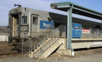
Wtby_Branch.png

Draft 2015-2018 Transportation Improvment Program Released

COGCNV has released a draft of its 2015-2018 Transportation Improvement Program (TIP) for public comment. The Transportation Improvement Program (TIP) is a four-year funding schedule of transportation improvement projects paid for by federal, state, and local funding sources. Highway and road improvements, bridge repairs, commuter services, and bus and train operating and capital funds are included in the TIP. The Connecticut Department of Transportation (CT DOT) is also seeking public comments on its draft Statewide Transportation Improvement Program (STIP): 2015-2018. 

Draft COGCNV TIP: 2015-2018 (PDF) >
Draft CTDOT STIP: 2015-2018 > 
Legal Notice (PDF) >

Air quality conformity assessments for Ozone and Particulate Matter 2.5 (PM2.5) were conducted by the Connecticut Department of Transportation to ensure that future transportation projects meet air quality standards set by the United States Environmental Protection Agency (EPA). Full air quality assessments can be found at the links below:

Air Quality Assessment for Ozone (PDF) > 
Air Quality Assessment for PM2.5 (PDF) > 

Public Comment Period

The Council of Governments of the Central Naugatuck Valley (COGCNV) will hold a public meeting for the Central Naugatuck Valley Region’s 2015-2018 Transportation Improvement Program (TIP) and Air Quality Conformity Assessments on Tuesday, September 30, 2014 from 5:00 P.M. to 7:00 P.M. The public is encouraged to ask questions and offer comments and suggestions about projects in the TIP. The COGCNV office is located at 49 Leavenworth Street, Suite 303, in Waterbury. Written comments can also be sent to COGCNV, 49 Leavenworth Street, Suite 303, Waterbury, CT 06702, or by email to pgallagher@cogcnv.org. Public comments will be accepted until October 22, 2014.

Air Quality Conformity Assessment Public Comments

Public Comments on Air Quality Conformity Assessments

The Council of Governments of the Central Naugatuck Valley (COGCNV) is seeking public comments related to air quality assessments for its 2015-2018 Transportation Improvement Program and Long Range Plan. Air quality assessments have been conducted on upcoming transportation projects to ensure that they meet the Ozone and PM 2.5 air quality standards established by the US Environmental Protection Agency. The full reports of the assessments, which were conducted by the Connecticut Department of Transportation (CT DOT), can be found below. 

CT DOT Ozone Report (PDF) >
CT DOT PM 2.5 Report (PDF) >
COGCNV Legal Notice (PDF) >

A thirty (30) day public comment period has been established beginning on September 17, 2014 and ending on October 17, 2014. A public meeting will be held on Tuesday, September 30, 2014 from 3:00 PM to 5:00 PM at the COGCNV offices at 49 Leavenworth Street, Suite 303, Waterbury CT 06702. Comments can also be submitted in writing or via email to Pat Gallagher, Senior Planner at pgallagher@cogcnv.org. 

TIGER grant heralds a big stride for city

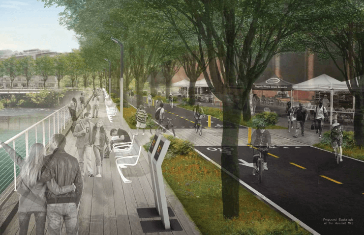
WATER-Esplenade-Anamet-Site-740.png

By Samuel Gold 

The chief elected officials of the Council of Governments of the Central Naugatuck Valley (COGCNV) congratulate Waterbury on its successful application to the U.S. Department of Transportation’s Transportation Improvement Generating Economic Recovery (TIGER) grant program. In March, COG voted unanimously to partner with the city on its Waterbury Active Transportation Economic Resurgence (WATER) project, and is excited to support the city on what will be a transformative project.

The project will extend Waterbury’s walkable, mixed-use downtown, increase transit accessibility, and redefine the city’s image around an enjoyable and attractive riverfront greenway. Investment in these improvements will support the city’s economic recovery and the larger regional economy. A reimagined and redeveloped Freight Street corridor will provide space for new businesses, including new medical offices near Waterbury’s hospitals. The corridor also will provide opportunities for development oriented to Metro-North commuter-rail service and the CTFastrak station.

No other location in the Central Naugatuck Valley region has the unrealized development potential of the Freight Street corridor. It is bounded by the region’s most significant transportation assets: the Interstate 84/Route 8 interchange, Metro-North terminal and the future Naugatuck River Greenway. The corridor is underutilized because it lacks basic connections to the transportation infrastructures that surround it.

The WATER project will construct the long-planned Jackson Street/Thomaston Avenue connector, and will connect the Freight Street corridor to West and South Main streets and to the region’s expressway network.

The up-and-over pedestrian bridge connecting to Library Park, and complete street retrofit of Freight and Meadow streets, will provide the pedestrian and bicycle connections needed to make transit-accessible development possible in the Freight Street corridor.

The most exciting and ambitious element of the WATER project is the Naugatuck River Greenway. With the extension of the Naugatuck River Greenway into the Freight Street corridor, this abandoned area, which no one thinks about or ventures to, becomes a real place that is desirable and special. The multi-use greenway trail will provide Waterbury residents and visitors a safe place to walk, bicycle, and access the now-clean Naugatuck River. As planned connections to neighborhoods and Naugatuck, Watertown, and Thomaston are completed, it will become an alternative transportation commuter facility as well.

As a partner in the WATER project, the COG will support the city with technical and administrative assistance, and ensure the coordination of Waterbury’s project with local, regional, state and federal transportation planning, design and capital projects.

This is an exciting time for Waterbury and the region. As Waterbury’s rejuvenation efforts achieve fruition, COGCNV is joining with six neighboring Naugatuck Valley municipalities to form a new, larger, and more capable Naugatuck Valley Council of Governments. We look forward to helping Waterbury and the Region realize the promise of the WATER project and the resurgence of the Naugatuck Valley.

Samuel Gold is executive director of COGCNV. 


For more information, please visit the City of Waterbury WATER Project Information Page.

NVCOG Off to a Great Start

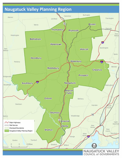
Map of the NVCOG Planning Region

BY ED EDELSON AND KURT MILLER 
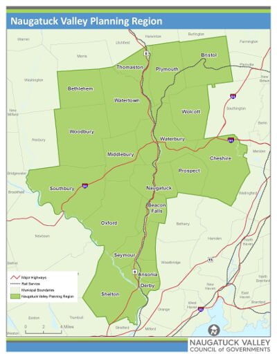
Map of the NVCOG Planning Region

Following certification by the Connecticut Office of Policy and Management (OPM), the newly formed Naugatuck Valley Council of Governments (NVCOG) held the first meeting of our municipal chief elected officials Aug. 22 at Hop Brook Lake in Middlebury. As chairmen of the current councils of governments covering the Naugatuck Valley area, we believe this step to align the 19 cities and towns around the urban center of Waterbury provides the best opportunity for all of our communities to combine resources, and bring significant new investment and cost savings to each of our communities. 

With a population of 448,738, the council brings together our common interests in highway and rail transportation, redevelopment of vacant brownfields and the revitalization of our riverfront downtowns. Our smaller suburban communities will benefit equally by this regional approach to economic development, and the ability to jointly deliver services at a scale that is more cost efficient for all of our taxpayers. 

The fact Mike Donnarumma, district superintendent of operation services for Metro-North Railroad, and James Redeker, commissioner of the state Department of Transportation, asked to attend this meeting demonstrates that others share this view. 

NVCOG will replace the Council of Governments Central Naugatuck Valley and the Valley Council of Governments, the current regional planning organizations. In addition, two towns from the Central Connecticut Council of Governments, Bristol and Plymouth, are part of the NVCOG. The new organization will serve five cities, 13 towns and one borough over 420 square miles, with 2,965 miles of roads. 

A Map of the NVCOG Planning RegionMap of NVCOG Planning RegionAs the respective chairmen of the two existing councils, we are enthusiastic about the possibilities of this larger region. We believe it will bring more focus to our transportation needs, which are critical to the future quality of life of our communities. We also are encouraged about the prospects of providing shared services, enabling us to take advantage of the economies of scale of a larger organization. Although our two current organizations have done high-quality work over the past four decades, we recognize they each have had different strengths and areas of focus. Bringing those strengths and experience together is a challenge and an exciting opportunity that will provide greater economic benefit to each of our municipalities. 

The new organization will have its offices in Waterbury at the current location of the Council of Governments of the Naugatuck Valley, where there is adequate space for expansion. It is expected that the staff from the Valley council will be relocated by early 2015. 

The formation of the NVCOG was part of an overall effort initiated by the legislature and implemented by OPM about a year ago. Before 2013, the state had 15 regional planning organizations. As a result of volunteer consolidations and the state’s 2014 redrawing of the boundaries of Connecticut’s planning regions, there now are nine regional planning organizations. The next challenge for the state is the consolidation of the Metropolitan Planning Organizations (MPOs), which are the federal regions that plan our transportation systems and jointly allocate federal funds for these projects with the Connecticut Department of Transportation. There currently are eight MPOs in Connecticut, and the direction is to have fewer MPOs with boundaries that coincide with the new councils of governments’ boundaries. 

The alphabet soup of regionalplanning and service-delivery entities can be daunting to new mayors, first selectman and citizens, but the need for wider regional cooperation in conducting transportation planning, economic development, water resources and social services cannot be denied. Because of the many small, overlapping regional organizations, Connecticut was unable to take advantage of the economies of scale offered by new technology or be as competitive for federal resources when it came up against the much larger counties and MPOs that prevail across the rest of the United States. No one municipality can prosper unless the whole region moves forward. 

At the same time, as first selectmen of small towns, we recognize the importance of maintaining the quality of life that comes from our unique communities. That means carefully choosing what is appropriate to be done on a regional basis versus what should continue to be delivered and controlled at the town level. We expect there will be a vibrant conversation about this in the coming years. 

We want to encourage that. 

Although we recognize the attractiveness of receiving services on a small-scale, personal level that appeals to our residents, we also recognize there is a high cost to providing many of these services, especially in comparison with the 48 other states that have county-level government. 

There are many reasons Connecticut is a high-tax state, but we no longer can afford to ignore the fact many services are delivered at an inefficient and expensive scale. 

At the same time, we recognize the importance of our new region’s major cities — such as Waterbury, Bristol and Shelton — as the economic engines. Their economic and social future is critical to all of the surrounding towns. We are all dynamically linked. We also must press our case that all of our communities provide the highly educated workforce that drives the economy. New investment in our transportation connections to other parts of the state are the most important factor in Connecticut’s economic growth. The problems and successes of one are shared by all. 

With the start of the new organization, we see many positive possibilities to help all 19 municipalities. 

This is an exciting time, and we are optimistic about the future of the new Naugatuck Valley Council of Governments. 

Ed Edelson, a Democrat, is first selectman of Southbury. Kurt Miller, a Republican, is first selectman of Seymour. They are co-chairmen of the Naugatuck Valley Council of Governments.