NVCOG Regional Profile Report Now Available

For Immediate Release:

Contact:
Glenda Prentiss
Naugatuck Valley Council of Governments
203-757-0535
gprentiss@nvcogct.gov

NVCOG Regional Profile Report Now Available

Naugatuck Valley Council of Governments (NVCOG) staff recently completed an update to the Regional Profile for the 19 municipalities comprising the NVCOG region. The Regional Profile compiles population, economic, and housing data from a variety of sources, including the U.S. Census Bureau, the Connecticut Department of Labor, and the Connecticut Department of Economic and Community Development.

This report provides useful statistical data to public officials, local organizations, developers, private citizens, students, businesses, and others interested in population, housing and economic trends. NVCOG staff prepares an update each year. The data is intended to assist municipalities with grant applications, updates to planning and economic development documents, and provide information to local boards and commissions. An analysis and overview of important regional trends is found in the beginning of the report. More detailed tables and maps showing information for each municipality are found in the appendices.

As a supplement to the Regional Profile, NVCOG staff has created an interactive web-based application to provide access to the U.S. Census Bureau’s American Community Survey data at the block group or block level. This tool allows users to obtain statistics for smaller areas within a municipality.

The Regional Profile report and web-based application can found on NVCOG’s website at www.nvcogct.org

“Just as the State of Connecticut is very diverse as a whole, the NVCOG region demonstrates considerable diversity in demographic data, which the Regional Profile summarizes well,” said NVCOG GIS Program Coordinator Glenda Prentiss. “Providing supplemental access to the U.S. Census Bureau’s American Community Survey data at the block group or block level is a new feature that offers the opportunity to provide even more specific data.”

(END)

State Conservation and Development Plan Update 2018 – 2023 – Public Hearing at NVCOG Offices September 8, 2017

The State Office of Policy and Management (OPM) held a public hearing regarding its draft Conservation and Development Plan 2018 – 2023 after the NVCOG Council meeting this past September 8, 2017. The slide presentation given prior to the public hearing may be viewed through the link above. Public review and comment period is underway – comments regarding the State Plan and its associated Locational Guide Map (LGM) are being accepted until October 16, 2017. For more information about the State’s Conservation and Development Plan Update for 2018 – 2023, and how to submit comments, visit the OPM website.

Naugatuck Valley Regional Profile 2016 now available!

NVCOG staff has just completed an update to the Regional Profile for the 19-municipality Naugatuck Valley Region. The Regional Profile compiles population, economic, and housing data from a variety of sources including the U.S. Census Bureau, the Connecticut Department of Labor, and the Connecticut Department of Economic and Community Development.

Naugatuck Valley Regional Profile 2016

As a supplement to the Regional Profile, NVCOG staff has created an interactive web-based application to provide access to the U.S. Census Bureau’s American Community Survey data at the block  group or block level. This tool allows users to obtain statistics for smaller areas within a municipality. The application can be accessed here:

Naugatuck Valley Regional Profile 2016 – Maps (Interactive web application)


Derby-Shelton Bridge Design Kick Off Meeting August 22

For Immediate Release: August 8, 2017
Contact:
Mark Nielsen  
Naugatuck Valley Council of Governments 
203-757-0535
mnielsen@nvcogct.org                                             

           Derby-Shelton Bridge Design Kick Off Meeting August 22 

The Naugatuck Valley Council of Governments will hold a stakeholder kick-off meeting on the design of renovations and enhancements to the Derby-Shelton Bridge over the Housatonic River on Tuesday, August 22 at the Avalon Shelton, 185 Canal St., Shelton at 6 p.m. The meeting will provide stakeholders an opportunity to meet the design team and learn about the project, including preliminary concept plans and an anticipated project timeline. 

The intent of the project is to create an aesthetically pleasing public space along the Derby-Shelton Bridge and provide an attractive gateway to the downtown areas of Derby and Shelton. It is being designed by AECOM under contract to the NVCOG. Construction will be advertised and administrated by the Connecticut Department of Transportation (CTDOT).  

The project will include: 

•           The replacement of bridge parapet walls; The new parapet will be either a solid concrete wall or include decorative railings; The railing treatment and its placement along the parapet can provide safety, as well as aesthetically attractive sightlines 

•           The removal of existing lighting and replacement with period style lights that both enhance the presence of the bridge at night and comply with dark sky guidelines; Additional lighting would be installed within the pedestrian plaza as needed 

•           Various roadway improvements, including the narrowing of the travel lanes to accommodate the public space and a bi-directional cycle-track to separate bicyclists from both vehicle traffic and pedestrians. 

•           The placement of benches that serve as a catalyst for creating a gathering or resting place, and encourage walkers to linger to enjoy the views of the river  

The project will also offer connectivity with the existing Housatonic Riverwalk trail network in Shelton and the Derby Greenway/Naugatuck River Greenway in Derby. The project limits will extend from the Bridge Street intersection with Main Street in Derby to the west end of the Derby-Shelton Bridge and includes the connections to Canal Street. 

The project is a direct outgrowth of a study completed by the Derby Shelton Rotary Club that recommended ornamental lighting, new sidewalks and curbing, decorative paving and accents, and ornamental railings as a way of creating a gateway between Derby and Shelton. A grant provided by the Connecticut Office of Policy and Management (OPM) further refined concepts and assessed alternatives. The state Bond Commission, under a request by State Representatives Themis Klarides, R-114, Jason Perillo, R-113, and Ben McGorty, R-122, authorized funds for the design and construction of improvements, and the CTDOT subsequently authorized federal transportation dollars to fully fund construction. 

“It has taken some time to get this project started,” said Mark Nielsen, NVCOG Director of Planning. “However, a lot people have been diligent in securing the funding needed to see the enhancements become a reality.” 

It is currently expected that the design will take 17 months to complete, with construction being bid in early 2019 and completed by the end of that calendar year. Any design must comply with historic preservation guidelines. Also, while travel lanes may be narrowed, there will be no reduction in roadway capacity. 


Draft State Water Plan Published For Review

CONNECTICUT WATER PLANNING COUNCIL SEEKS PUBLIC COMMENT ON DRAFT OF STATE WATER PLAN

Finalized Plan to be Presented to the Governor and Legislature in 2018

(HARTFORD, CT) – The members of the Connecticut Water Planning Council (WPC) today announced that they have published a draft version of the State Water Plan that they have been developing onto the council’s website (www.ct.gov/water) and have opened a public review period to give Connecticut residents, businesses, and other stakeholders an opportunity to provide feedback before it is finalized early next year. Between July 20 and November 20, 2017, interested parties will have an opportunity to review the draft plan and provide the group with their comments.

The draft plan recommends a framework for managing Connecticut’s water into the future and for achieving balance with our many human and environmental needs as climate trends emerge and new needs develop. It addresses the quality and quantity of water for drinking, ecology, recreation, business, industry, agriculture, energy, and wastewater assimilation.

The WPC members stressed that the input of Connecticut’s citizens is crucial to the development and implementation of the plan to ensure it is fair and effective at balancing the needs of all water users while protecting a valuable resource.

The creation of the State Water Plan was required following the adoption of a new state law, Public Act 14-163, which directed the WPC to formulate a plan that will help planners, regulators, and lawmakers make decisions about managing Connecticut’s water in a manner that is consistent throughout the state. The group’s draft plan reflects the input of various stakeholders, committee members and public participants. They intend to present a final document to the Governor and various legislative committees in 2018.

The council will hold public hearings on the draft plan across the state during late summer and fall, and they will also use technological resources to advertise and educate the public on the plan throughout this period. Details of the WPC’s public outreach efforts, information on how to comment, and links to other resources will be available in the coming weeks at www.ct.gov/water.

The WPC is comprised of four members: John W. Betkoski (Chair), Vice Chairman, Public Utilities Regulatory Authority; Garrett Eucalitto, Undersecretary, Office of Policy and Management; Betsey Wingfield, Bureau Chief, Department of Energy and Environmental Protection; and Lori Mathieu, Drinking Water Section Chief, Department of Public Health.

A copy of the draft plan and associated resources can be found at www.ct.gov/water

NVCOG Study to Determine Effective Transportation Opportunities Underway

Contact: 
Mark Nielsen
Naugatuck Valley Council of Governments
203-757-0535
mnielsen@nvcogct.org                                           

NVCOG Study to Determine Effective Transportation Opportunities Underway

 The Naugatuck Valley Council of Governments has initiated a major planning study to assess opportunities for implementing alternative transit modes within the Route 8 / Waterbury branch rail line corridors and developing transit-supportive land use plans in and around the corridor’s commuter rail stations. 

Since the project kick-off meeting in late May, the study team has completed several preliminary study tasks, including assessment of existing transit systems and holding coordination meetings with the region’s various transit providers. The team, comprised of several consulting firms, has completed collecting information and data on the existing conditions within the corridor, which will be incorporated into upcoming design workshops. Study recommendations will be provided to the state Department of Transportation, with a goal of incorporating improvements in the corridor into the department’s capital plan. They will also be provided to area municipalities and the region’s state legislative delegation. Working toward developing a strategy and plan for implementing preferred options, the study is scheduled to be completed in late 2018.

As a starting point, previous studies were reviewed to better understand concepts that have been assessed.  Next steps in the project timeline include a series design workshops to be scheduled in September. The events will provide stakeholders and the public opportunities to learn about innovative transit options and influence decisions on mixed-use land patterns that would complement and support transit services. 

“The primary goal of the study is to identify enhanced transit services that would be the catalyst for revitalizing the town centers along the corridor,” said Mark Nielsen, NVCOG Assistant Director/Director of Planning. “Regarding rail service, these communities have a tremendous advantage over other similar communities because such infrastructure is already in place. However, the infrastructure needs to be improved and rehabilitated to permit the frequency and level of service needed to attract people to live and work in the corridor. Bus Rapid Transit along Route 8 south of Derby is also among the modes being considered.”

The biggest factor impeding enhanced service on the Waterbury branch line is related to the equipment, added Nielsen. There are too few trainsets assigned to the line, and more frequent service is not possible without an increase in the number of trains assigned to the line and upgrades in equipment to address the frequent equipment breakdowns that occur.

The study team firms and assigned tasks:

 •AECOM – Prime Consultant

•CDM Smith – TOD Scenarios, Forecasting

•Harriman – TOD Scenarios, Urban Design

•Planning4Places DBE – Planning Support, Build Out Scenarios

•Zuvic & Carr Associates SBE – Data Collection, Parking Inventory

Stated study goals are:

1.Identify new, enhanced and alternate public transit facilities and services, including local bus service, bus rapid transit routes and commuter rail, to transform town centers into vibrant, high-density communities that have access to efficient and high quality transit services. 

2.Provide built environment densities that meet transit supportive standards for land uses and walkability, in order to facilitate and encourage the use of enhanced transit services.

3.Enhance transit connectivity, reliability and attractiveness. 

4.Develop an implementation plan for incentivizing transit oriented and supported developments in the lower Naugatuck Valley Region.

5.Advance Housing and Urban Development’s (HUD) livability principles and extend sustainable communities.  

The project study area extends from the City of Waterbury in the north to downtown Bridgeport in the south. The principle study corridors are the Route 8/25 Expressway from the Borough of Naugatuck to downtown Bridgeport, the Waterbury Branch Rail Line from Naugatuck to the Devon Wye at the New Haven Main Rail Line, the town centers of Derby, Shelton, Ansonia, Seymour, Beacon Falls and Naugatuck, and the Bridgeport Avenue corporate corridor in Shelton and Trumbull.

A project website has been developed and is live at: http://rt8corridorstudy.com. Interested persons can contact the study team through the “Contact Us” page which lists several ways the public can contact the Team to offer comment or ask questions. An email address has also been established to contact the Team: rt8corridorstudy@nvcog.org. 


NVCOG Receives Greenways Regional Achievement Award

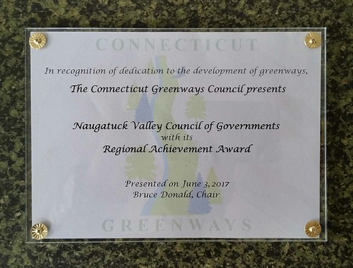
The Connecticut Greenways Council awarded its Regional Acheivement Award to The Naugatuck Valley Council of Governments “in recognition of dedication to the development of greenways“. The award was presented by Connecticut Greenways Council Chairman Bruce Donald at the 18th Annual Greenway Awards & National Trails Day Celebration on June 2nd in Stamford. In presenting the award, Donald praised NVCOG’s work in support of the Naugatuck River Greenway (NRG) and NRG Steering Committee, and work on several greenway related projects including the NRG Economic Impact Study, The NRG Unified Wayfinding and Signage Manual, and the CT Trail Census.  More information HERE

CGC Award

Assessment Study Details Major Economic, Quality of Life Benefits of Completing Naugatuck River Greenway Trail

Contacts: 
Mark Nielsen                                                              Laura Brown
Naugatuck Valley Council of Governments               UConn Extension Community and
203-757-0535                                                            Economic Development Program
mnielsen@nvcogct.org                                              (860) 207-0063
                                                                                   laura.brown@uconn.edu

 Assessment Study Details Major Economic, Quality of Life Benefits of Completing 
Naugatuck River Greenway Trail

The final report on the potential economic and quality of life benefits from the complete construction of the Naugatuck River Greenway, a planned multi-use, active transportation route along the river, was released today. The results of the study indicate the benefits could be substantial. The Naugatuck River Greenway (NRG) Steering Committee approved the study for release. It is designed to assist each of the 11 greenway municipalities and local greenway committees in evaluating efforts to complete sections of trail in their communities and determining the financial viability of investing in its construction. A draft of the study was released earlier, in January, to provide an opportunity for peer review and comment, as well as a way to vet the methodologies and assumptions. Based on comments received and further discussion by and among the Steering Committee and research team, adjustments were made to the previously released economic benefits. While the estimated economic benefits shown in the final report are lower than those included in the draft report, the results remain compelling and indicate a high return on the investment in the construction.

The planned NRG Trail will follow the Naugatuck River for 44 miles bringing the trail through parts of Torrington, Litchfield, Harwinton, Thomaston, Watertown, Waterbury, Naugatuck, Beacon Falls, Seymour, Ansonia and Derby. Planning, design and construction is taking place in sections, with each community securing land and construction funding within their respective boundaries.

The study indicates the direct construction expenditures for the NRG are expected to reach $77.2 million (2015 dollars) by the year 2030. However, this total cost pales in comparison of the total potential economic benefits that would accrue to host communities and the entire region at large. The research team investigated direct economic benefits in terms of annual spending by visitors to the trails, monetized health benefits, and amenity benefits derived by living close to the trail. Indirect and induced economic impacts were estimated based on expected changes to the county and state level economies from these direct inputs.

The study was based on complete construction of the NRG by 2030 with it being fully operational in 2031. Three analysis scenarios were modelled: baseline, moderate growth in visitations and an accelerated growth pattern that would result in a doubling of the number of users by 2013. To be conservative in the analysis, the results focus on the baseline case.

Currently, total annual visits to open sections, only about 4.1 miles in four communities, is estimated at about 195,500. These visitors spend about $2.9 million each year on various items such as snacks, beverages, food, gear and travel. By 2031, annual visitations are projected at 2.6 million and annual spending would reach about $42.6 million under the baseline scenario.

The study also looked at the potential health benefits that would accrue to users who frequently use the trail. Reports published by the US Surgeon General indicate that  moderate and frequent exercise could reduce the incidence of various medical conditions such as obesity, diabetes and cardiovascular disease, as well as various forms of cancer, including breast cancer. Trails have been proven to be convenient, safe and non-threatening places for people to exercise and realize health benefits. By 2031, the monetized value of reducing the incidences of these diseases and avoiding premature death would amount to about $260 million. This is based on the estimated number of people who would frequently visit the NRG and the dollar value of an avoided premature death as provided in the Surgeon General report.

Amenity benefits were also estimated. This is based on the value that people realize by living close to the trail compared to those who must travel longer distances to consume the same amenity. By 2031, this amenity benefit would total about $34.6 million, up from the current value of $5.1 million.

The regional economies of New Haven and Litchfield counties, as an aggregate, would also benefit from the construction of the trail. In 2031, indirect and induced impacts would increase personal disposable income by $91 million and expand Real Gross Domestic Product (RDGP) by $43 million (in 2009 dollars). About 516 jobs would be added and the area would support an increase of about 1,200 in population. The NRG Economic Impact Study was conducted by the Connecticut Center for Economic Analysis (CCEA), a University Center located in the School pf Business at the University of Connecticut, in collaboration with the UConn College of Agriculture, Health and Natural Resources Extension program in Community & Economic Development (Extension). It was published by the Naugatuck Valley Council of Governments (NVCOG) in partnership with the Northwest Hills Council of Governments (NHCOG). 

The project was guided by the NRG Steering Committee, a group made up of representatives of the 11 greenway communities, state and federal representatives, and other key stakeholders. Funding to conduct the study was received from The Connecticut Community Foundation, The Valley Community Foundation, The Community Foundation of Northwest Connecticut and The Katharine Matthies Foundation. 


“The study includes extensive, compelling data for creating the NRG,” said NRG Steering Committee Co-Chair Ingrid Manning. “While it would be a substantial construction cost, the investment could bring major economic benefits. Improved quality of life and economic well-being of area residents via increased property values, health benefits and economic growth are goals shared throughout the region. However, to realize these benefits it will be important for the communities to properly plan, promote and support the greenway, and encourage people to use it.”

 
In the weeks ahead, the NRG Steering Committee and project partners will present study findings to municipal officials, developers, development agencies and the public both electronically and via an outreach forum. The NRG corridor has been officially designated as a greenway by the CT Greenways Council and the CT Department of Energy and Environmental Protection (DEEP). The entire greenway trail is identified as a trail of statewide significance in the Connecticut Recreational Trails Plan, and it was designated as one of 101 America’s Great Outdoors projects in 2011 by the U. S. Department of the Interior. 


The complete study can be found at:

http://nvcogct.org/sites/default/files/pictures/headers/NRG-EconomicReport-FinalDraft-Spreads.pdf

Additional information can be found at www.NaugatuckRiver.net , at www.nvcogct.org, and at http://communities.extension.uconn.edu/.