Enhancing Pedestrian Safety
The Naugatuck Valley Council of Governments (NVCOG), in collaboration with the Connecticut Department of Transportation and the Town of Middlebury, Connecticut, is conducting an assessment of safety along Route 64 in Middlebury, with a focus on enhancing pedestrian and bicyclist connections and access throughout the corridor.
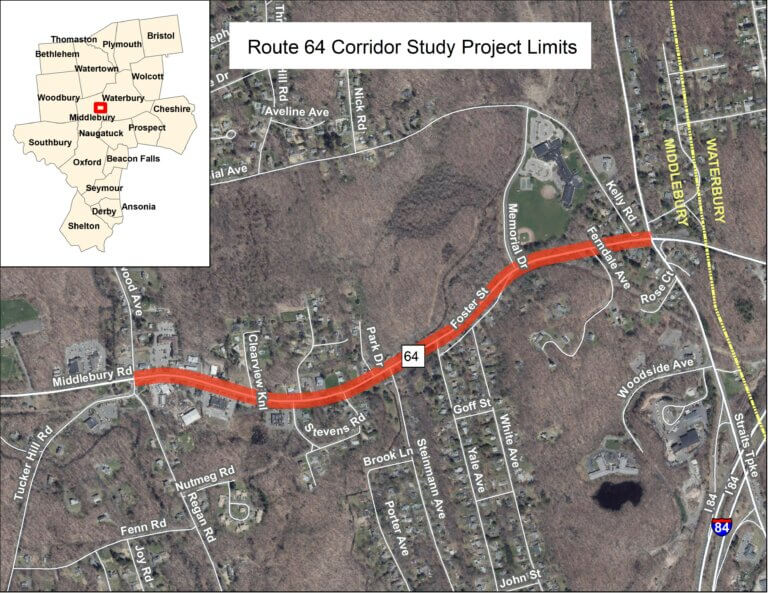
Improving Connectivity
The study area centers on a section of Route 64 between Glenwood Avenue and Route 63. Route 64 is a vital road in Middlebury linking the town to Waterbury and Woodbury. It also connects to I-84, US Route 6, and Route 188.
Land uses along the corridor feature preservation and residential districts with intermittent commercial zones at intersections. Adjacent to and along the southern side of the corridor is the Middlebury Greenway, which provides a road-separated path for walkers and bicyclists.
However, access to the Greenway from areas on the north side is limited.
Goals
The overall goal of the study is to improve access and connections to the Greenway, address safety concerns, and create a safer environment for all travelers within the corridor, especially the more vulnerable users. The CTDOT has initiated plans to reconstruct the I-84 interchange with Route 63 and realign and widen the Route 64 and Route 63 intersection. The town has expressed concern that the state project will not adequately accommodate vulnerable road users. Therefore, a key focus of the study is how the realignment of the intersection of Route 64 and Route 63 will affect pedestrian and bicyclist safety through the area.
The study area shifts from commercial, featuring restaurants, gas stations, banks, and small businesses, at Glenwood Avenue to residential districts along Route 64 to the Route 63 intersection.
Traffic signals are present at two locations along Route 64:
- Traffic signal at the intersection with Glenwood Avenue.
- Traffic signal at Route 63.
While sidewalks are present in parts of the commercial district, other sections lack them.
The Middlebury Greenway is the principal feature for pedestrians, bicyclists and others traveling by a micromobility device. However, better access and connections are needed.
Data Findings
Safety is a concern along the corridor. Over the most recent three-year period, approximately 21% of all crashes, as well as 28% of crashes involving an injury of any severity, occurred within the study area. The study entails robust data collection and comprehensive analyses of corridor infrastructure, traffic patterns, and crashes. in collaboration with various stakeholders and field experts.
Deliverables
The study will develop conceptual engineering drawings of preferred alternatives and an implementation plan laying out how to advance recommended improvements. Study reports and technical memoranda will be prepared and made available throughout the conduct of the project, culminating in a final report which will present key findings and recommendations.
Study Duration
It is anticipated that the study will be completed within an 18-month timeline.
Public Involvement Process
The NVCOG team is committed to engaging the public and interested stakeholders throughout the study and reaching out to as broad an audience as possible.
- The study will be guided by a Project Advisory Committee, comprised of interested stakeholders from the town.
- A Technical Advisory Committee will also be convened that will provide advice on the feasibility and effectiveness of concepts.
Please contact Kevin Ellis at kellis@nvcogct.gov with any questions, comments or concerns.
Public Meetings
A series of public meetings will be held for the purpose of sharing findings and hearing comments directly from the community and those who use the corridor regularly. Suggested improvements will be presented, and attendees will be provided with the opportunity to offer comments.
- These meetings will be open to all.
- Virtual options will be provided for all meetings as well to ensure the broadest participation.
- If you cannot attend, all meetings will be recorded and put onto the website and YouTube.
Road Safety and Walk Audit
To better understand and learn about the challenges that vulnerable road users face traveling along the corridor, a field walk will be conducted by the NVCOG.
- Town elected officials, town engineering, planning and public works representatives, public safety, CTDOT, and other interested persons, as well as anyone from the public will be invited to join.
- This will serve both as an opportunity to gather site information about the condition of the area and as an educational opportunity for members of the study team and community to share safety standards and discuss potential improvements.
Stay Updated on Social Media
In addition to this page, NVCOG staff will keep you up-to-date regarding the project’s status and progress on NVCOG’s social media platforms, which include Facebook, Instagram, Twitter, and LinkedIn.
Helpful Resources
Resources related to this study will be uploaded here when available.