Skip to content
  • Public Notices
  • Publications
  • Maps & Data
  • Your Transit Rights
  • en English
    en Englishes Españolaf Afrikaanssq Shqipam አማርኛar العربيةhy Հայերենaz Azərbaycan dilieu Euskarabe Беларуская моваbn বাংলাbs Bosanskibg Българскиca Catalàceb Cebuanony Chichewazh-CN 简体中文zh-TW 繁體中文co Corsuhr Hrvatskics Čeština‎da Dansknl Nederlandseo Esperantoet Eestitl Filipinofi Suomifr Françaisfy Fryskgl Galegoka ქართულიde Deutschel Ελληνικάgu ગુજરાતીht Kreyol ayisyenha Harshen Hausahaw Ōlelo Hawaiʻiiw עִבְרִיתhi हिन्दीhmn Hmonghu Magyaris Íslenskaig Igboid Bahasa Indonesiaga Gaeligeit Italianoja 日本語jw Basa Jawakn ಕನ್ನಡkk Қазақ тіліkm ភាសាខ្មែរko 한국어ku كوردی‎ky Кыргызчаlo ພາສາລາວla Latinlv Latviešu valodalt Lietuvių kalbalb Lëtzebuergeschmk Македонски јазикmg Malagasyms Bahasa Melayuml മലയാളംmt Maltesemi Te Reo Māorimr मराठीmn Монголmy ဗမာစာne नेपालीno Norsk bokmålps پښتوfa فارسیpl Polskipt Portuguêspa ਪੰਜਾਬੀro Românăru Русскийsm Samoangd Gàidhligsr Српски језикst Sesothosn Shonasd سنڌيsi සිංහලsk Slovenčinasl Slovenščinaso Afsoomaalisu Basa Sundasw Kiswahilisv Svenskatg Тоҷикӣta தமிழ்te తెలుగుth ไทยtr Türkçeuk Українськаur اردوuz O‘zbekchavi Tiếng Việtcy Cymraegxh isiXhosayi יידישyo Yorùbázu Zulu
Menu
  • Public Notices
  • Publications
  • Maps & Data
  • Your Transit Rights
  • en English
    en Englishes Españolaf Afrikaanssq Shqipam አማርኛar العربيةhy Հայերենaz Azərbaycan dilieu Euskarabe Беларуская моваbn বাংলাbs Bosanskibg Българскиca Catalàceb Cebuanony Chichewazh-CN 简体中文zh-TW 繁體中文co Corsuhr Hrvatskics Čeština‎da Dansknl Nederlandseo Esperantoet Eestitl Filipinofi Suomifr Françaisfy Fryskgl Galegoka ქართულიde Deutschel Ελληνικάgu ગુજરાતીht Kreyol ayisyenha Harshen Hausahaw Ōlelo Hawaiʻiiw עִבְרִיתhi हिन्दीhmn Hmonghu Magyaris Íslenskaig Igboid Bahasa Indonesiaga Gaeligeit Italianoja 日本語jw Basa Jawakn ಕನ್ನಡkk Қазақ тіліkm ភាសាខ្មែរko 한국어ku كوردی‎ky Кыргызчаlo ພາສາລາວla Latinlv Latviešu valodalt Lietuvių kalbalb Lëtzebuergeschmk Македонски јазикmg Malagasyms Bahasa Melayuml മലയാളംmt Maltesemi Te Reo Māorimr मराठीmn Монголmy ဗမာစာne नेपालीno Norsk bokmålps پښتوfa فارسیpl Polskipt Portuguêspa ਪੰਜਾਬੀro Românăru Русскийsm Samoangd Gàidhligsr Српски језикst Sesothosn Shonasd سنڌيsi සිංහලsk Slovenčinasl Slovenščinaso Afsoomaalisu Basa Sundasw Kiswahilisv Svenskatg Тоҷикӣta தமிழ்te తెలుగుth ไทยtr Türkçeuk Українськаur اردوuz O‘zbekchavi Tiếng Việtcy Cymraegxh isiXhosayi יידישyo Yorùbázu Zulu
NVCOG CT - Naugatuck Valley Council of Governments
  • Who We Are
    • A Council of Governments
    • A Metropolitan Planning Organization
    • Committees and Commissions of the COG
      • Overview
      • NRG Steering Committee
      • Regional Planning Commission
      • Transportation Technical Advisory Committee (TTAC)
      • Regional Brownfields Partnership
      • Emergency Planning Committee / Citizen Corps Council
    • Our Region
      • Overview
      • History
      • Exploring Our Region
    • Contact / Staff
    • Directions & Parking
    • Annual Reports
    • Funding Sources
  • What We Do
    • Transportation Planning
      • Overview
      • Air Quality Conformity
      • Highway Safety Program
      • LOTCIP
      • Active Transportation Program
      • Transit
      • Transportation Improvement Programs
      • Metropolitan Transportation Plan
      • Work Program (UPWP)
    • Metropolitan Area Planning Forum
    • Land Use
    • Brownfields Program
      • Overview
      • Funding
        • Assessment Grants
        • Revolving Loan Fund
        • RLF Application
    • Environment
      • Overview
      • Dam Safety
      • MS4
      • Regional Trails
    • Emergency Management
      • Overview
      • Diversion Routes
      • Pre-Disaster Mitigation Plans
      • Regional Emergency Support Plan
    • Naugatuck River Greenway
      • Overview
      • 2010 NRG Routing Studies
      • NRG Economic Impact Study
      • NRG Signage Program
    • Municipal Shared Services
      • Overview
      • Household Hazardous Waste
      • Public Works Equipment Sharing Database
      • Regional Election Monitor
    • Economic Development
    • Grants
  • Current Projects
    • Roadway Projects
      • Derby-Shelton Bridge Pedestrian and Bicyclist Enhancements
      • Route 67 Seymour – Spot Improvements
      • Route 34 Main Street Derby Reconstruction
    • Transportation Planning Studies
      • Route 8 & Waterbury Branch Line Corridor/Alternative Modes Study
      • Oxford Route 67 Alternative Transportation Study
      • Bristol Route 229 Corridor Study
      • Waterbury West Main Street Corridor Study
    • Brownfields
    • Ansonia-Derby Regional School Study
    • Regional Wastewater Treatment Consolidation Study
    • Kinneytown Dam Fish Passage
    • Naugatuck River Greenway
      • NRG Thomaston – Watertown Design & Construction
      • NRG Trail Thomaston to Torrington Routing Feasibility Study
    • Regional Hazard Mitigation Plan Update
    • Regional Plan of Conservation and Development
    • Archived Projects
  • Calendar
  • Our Towns
Menu
  • Who We Are
    • A Council of Governments
    • A Metropolitan Planning Organization
    • Committees and Commissions of the COG
      • Overview
      • NRG Steering Committee
      • Regional Planning Commission
      • Transportation Technical Advisory Committee (TTAC)
      • Regional Brownfields Partnership
      • Emergency Planning Committee / Citizen Corps Council
    • Our Region
      • Overview
      • History
      • Exploring Our Region
    • Contact / Staff
    • Directions & Parking
    • Annual Reports
    • Funding Sources
  • What We Do
    • Transportation Planning
      • Overview
      • Air Quality Conformity
      • Highway Safety Program
      • LOTCIP
      • Active Transportation Program
      • Transit
      • Transportation Improvement Programs
      • Metropolitan Transportation Plan
      • Work Program (UPWP)
    • Metropolitan Area Planning Forum
    • Land Use
    • Brownfields Program
      • Overview
      • Funding
        • Assessment Grants
        • Revolving Loan Fund
        • RLF Application
    • Environment
      • Overview
      • Dam Safety
      • MS4
      • Regional Trails
    • Emergency Management
      • Overview
      • Diversion Routes
      • Pre-Disaster Mitigation Plans
      • Regional Emergency Support Plan
    • Naugatuck River Greenway
      • Overview
      • 2010 NRG Routing Studies
      • NRG Economic Impact Study
      • NRG Signage Program
    • Municipal Shared Services
      • Overview
      • Household Hazardous Waste
      • Public Works Equipment Sharing Database
      • Regional Election Monitor
    • Economic Development
    • Grants
  • Current Projects
    • Roadway Projects
      • Derby-Shelton Bridge Pedestrian and Bicyclist Enhancements
      • Route 67 Seymour – Spot Improvements
      • Route 34 Main Street Derby Reconstruction
    • Transportation Planning Studies
      • Route 8 & Waterbury Branch Line Corridor/Alternative Modes Study
      • Oxford Route 67 Alternative Transportation Study
      • Bristol Route 229 Corridor Study
      • Waterbury West Main Street Corridor Study
    • Brownfields
    • Ansonia-Derby Regional School Study
    • Regional Wastewater Treatment Consolidation Study
    • Kinneytown Dam Fish Passage
    • Naugatuck River Greenway
      • NRG Thomaston – Watertown Design & Construction
      • NRG Trail Thomaston to Torrington Routing Feasibility Study
    • Regional Hazard Mitigation Plan Update
    • Regional Plan of Conservation and Development
    • Archived Projects
  • Calendar
  • Our Towns
Search
Close
Menu
Search
Close
  • Public Notices
  • Publications
  • Maps & Data
  • Your Transit Rights
  • en English
    en Englishes Españolaf Afrikaanssq Shqipam አማርኛar العربيةhy Հայերենaz Azərbaycan dilieu Euskarabe Беларуская моваbn বাংলাbs Bosanskibg Българскиca Catalàceb Cebuanony Chichewazh-CN 简体中文zh-TW 繁體中文co Corsuhr Hrvatskics Čeština‎da Dansknl Nederlandseo Esperantoet Eestitl Filipinofi Suomifr Françaisfy Fryskgl Galegoka ქართულიde Deutschel Ελληνικάgu ગુજરાતીht Kreyol ayisyenha Harshen Hausahaw Ōlelo Hawaiʻiiw עִבְרִיתhi हिन्दीhmn Hmonghu Magyaris Íslenskaig Igboid Bahasa Indonesiaga Gaeligeit Italianoja 日本語jw Basa Jawakn ಕನ್ನಡkk Қазақ тіліkm ភាសាខ្មែរko 한국어ku كوردی‎ky Кыргызчаlo ພາສາລາວla Latinlv Latviešu valodalt Lietuvių kalbalb Lëtzebuergeschmk Македонски јазикmg Malagasyms Bahasa Melayuml മലയാളംmt Maltesemi Te Reo Māorimr मराठीmn Монголmy ဗမာစာne नेपालीno Norsk bokmålps پښتوfa فارسیpl Polskipt Portuguêspa ਪੰਜਾਬੀro Românăru Русскийsm Samoangd Gàidhligsr Српски језикst Sesothosn Shonasd سنڌيsi සිංහලsk Slovenčinasl Slovenščinaso Afsoomaalisu Basa Sundasw Kiswahilisv Svenskatg Тоҷикӣta தமிழ்te తెలుగుth ไทยtr Türkçeuk Українськаur اردوuz O‘zbekchavi Tiếng Việtcy Cymraegxh isiXhosayi יידישyo Yorùbázu Zulu
  • Who We Are
    • A Council of Governments
    • A Metropolitan Planning Organization
    • Committees and Commissions of the COG
      • Overview
      • NRG Steering Committee
      • Regional Planning Commission
      • Transportation Technical Advisory Committee (TTAC)
      • Regional Brownfields Partnership
      • Emergency Planning Committee / Citizen Corps Council
    • Our Region
      • Overview
      • History
      • Exploring Our Region
    • Contact / Staff
    • Directions & Parking
    • Annual Reports
    • Funding Sources
  • What We Do
    • Transportation Planning
      • Overview
      • Air Quality Conformity
      • Highway Safety Program
      • LOTCIP
      • Active Transportation Program
      • Transit
      • Transportation Improvement Programs
      • Metropolitan Transportation Plan
      • Work Program (UPWP)
    • Metropolitan Area Planning Forum
    • Land Use
    • Brownfields Program
      • Overview
      • Funding
        • Assessment Grants
        • Revolving Loan Fund
        • RLF Application
    • Environment
      • Overview
      • Dam Safety
      • MS4
      • Regional Trails
    • Emergency Management
      • Overview
      • Diversion Routes
      • Pre-Disaster Mitigation Plans
      • Regional Emergency Support Plan
    • Naugatuck River Greenway
      • Overview
      • 2010 NRG Routing Studies
      • NRG Economic Impact Study
      • NRG Signage Program
    • Municipal Shared Services
      • Overview
      • Household Hazardous Waste
      • Public Works Equipment Sharing Database
      • Regional Election Monitor
    • Economic Development
    • Grants
  • Current Projects
    • Roadway Projects
      • Derby-Shelton Bridge Pedestrian and Bicyclist Enhancements
      • Route 67 Seymour – Spot Improvements
      • Route 34 Main Street Derby Reconstruction
    • Transportation Planning Studies
      • Route 8 & Waterbury Branch Line Corridor/Alternative Modes Study
      • Oxford Route 67 Alternative Transportation Study
      • Bristol Route 229 Corridor Study
      • Waterbury West Main Street Corridor Study
    • Brownfields
    • Ansonia-Derby Regional School Study
    • Regional Wastewater Treatment Consolidation Study
    • Kinneytown Dam Fish Passage
    • Naugatuck River Greenway
      • NRG Thomaston – Watertown Design & Construction
      • NRG Trail Thomaston to Torrington Routing Feasibility Study
    • Regional Hazard Mitigation Plan Update
    • Regional Plan of Conservation and Development
    • Archived Projects
  • Calendar
  • Our Towns

Bristol Route 229 Corridor Study

  1. Home
  2. Projects
  3. Current Projects
  4. Transportation Planning Studies
  5. Bristol Route 229 Corridor Study
Project Overview
Get Involved
Survey & Map
Timeline
Documents
Project Overview

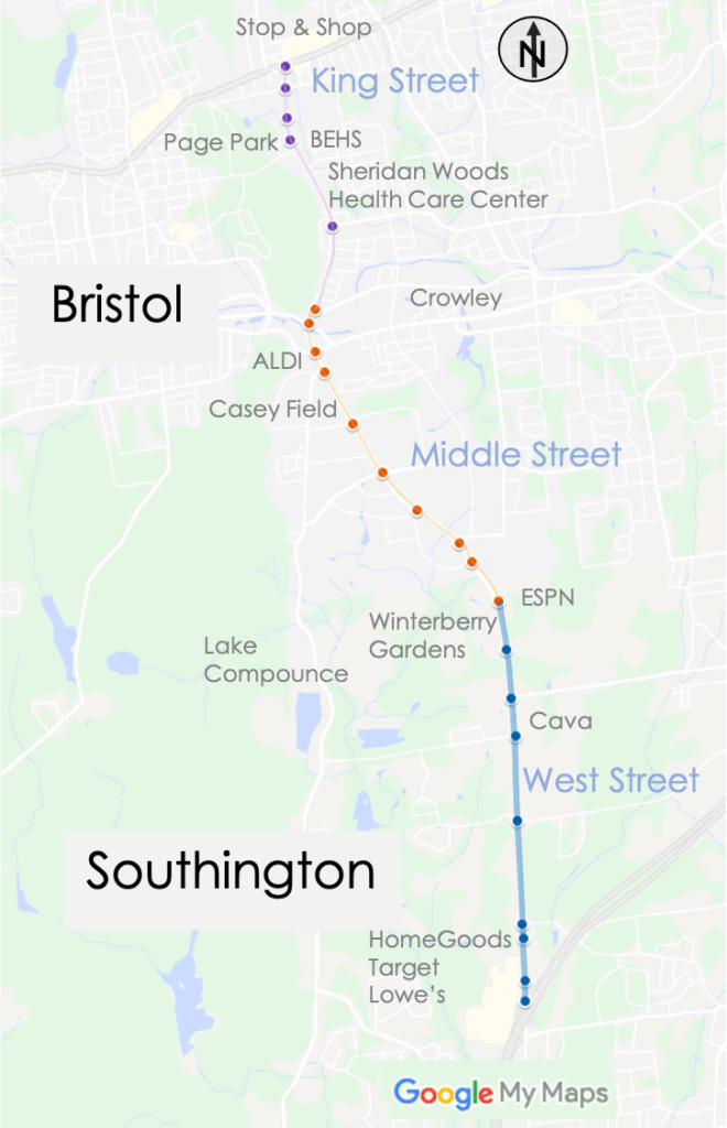
The NVCOG in collaboration with the CTDOT, the City of Bristol, and the Town of Southington has engaged a multidisciplinary team to conduct a corridor study along CT Route 229 between Interstate 84 and US Route 6. The intent of the study is to plan for future development while addressing safety and traffic flow concerns, and provide for improved pedestrian, bicycle, and transit-user accessibility. 

Route 229 is characterized by a variety of typologies and traverses diverse land uses. North of Route 72, King Street is a two-lane road through a residential neighborhood, providing access to the Route 6 commercial district and Bristol Eastern High School. At Broad Street, Route 229 widens to multiple lanes in both directions. The intersections of Middle Street and Route 72 and Middle Street and Pine Street/Mountain Road are of particular hazard due to high vehicle volumes, multiple lanes, and a large number of vehicles entering and exiting the roadway. This section of roadway is a hotspot for crashes. South of Pine Street, Route 229 becomes a four-lane undivided highway and remains four lanes until the Southington town line. This is a regionally significant commercial and industrial district and a significant employment center. The region’s largest employer, ESPN, is located on Middle Street, just north of the Southington town line. Additionally, the seasonal theme park, Lake Compounce, is accessed from Middle Street. The corridor’s only transit route, CTfastrak, services the Lake Avenue park-and-ride. At the Southington town border, the road narrows to one southbound lane and is the site of recurring congestion. The road remains as such until roughly 1500 feet north of I-84 Interchange 31. Land use throughout the West Street portion of the corridor is a mix of commercial and residential with several substantial business parks located in the close vicinity on intersecting streets. 

As part of the study, we will collect and analyze traffic and safety data, work with the public to identify weaknesses and opportunities along the corridor, propose countermeasures to improve safety and traffic flow, produce a final report summarizing the analysis and recommendations, and provide conceptual engineering drawings for spot improvements along the length of the corridor needed to create a safer environment for all users, better traffic flow and support ongoing economic development. 

The study is being conducted by a team of planning experts and key stakeholders, led by BL Companies., a multi-discipline firm with extensive expertise in planning and traffic engineering. Additional expertise in real estate market trends and land use demand is being provided by The Williams Group.

Staff Contact:

Christian Meyer
Supervising Transportation Planner
cmeyer@nvcogct.gov

Get Involved

Public Involvement Process

We strive to create a public involvement process that is collaborative, accessible and inclusive. During the course of the study, our team will use a variety of tools to engage the public in a discussion and dialogue regarding the future of Route 229 and how future improvements can better integrate all users. 

We will conduct interviews with stakeholders, prepare an online survey, develop an interactive map, conduct public information meetings, and provide frequent updates via this website and NVCOG’s social media platforms. Additionally, all documents related to the project will be posted to this website. All are encouraged to participate in this project. If you have a question or would like to provide a comment, suggestion or have an idea, please email here.  

Stakeholder Interviews

We will conduct several in depth interviews with key project stakeholders such as business owners and daily users along the corridor. The goal of this effort is to have in-depth conversations about issues and opportunities along Route 229 and to incorporate this feedback into the recommendations for improvements.  

Public Meetings

Three public meetings will be conducted with the dual purpose of sharing our findings and hearing directly from the community about their concerns and ideas for Route 229. These meetings are open to all. If you cannot attend, all meetings will be recorded and put onto the website. The first meeting will be a virtual workshop format. The schedule and format of Meetings #2 and #3 will be subject to public health limitations/guidance regarding in-person gatherings. 

Social Media

In addition to this website, we will keep you up-to-date regarding the project’s status and progress on NVCOG’s social media platforms, which include Facebook, Twitter, and LinkedIn. Follow us there! 

Survey & Map
Survey coming soon!
Timeline

Timeline/Schedule for the Route 229 Corridor Study

Documents

Future documents related to this study will be available here.

A Council of Governments & Metropolitan Planning Organization

Employment
Website Feedback
For Vendors
Contact Us
For Staff
Glossary

The Naugatuck Valley Council of Governments is proud to be an Equal Employment Opportunity and Affirmative Action employer. We do not discriminate based upon race, religion, color, national origin, gender (including pregnancy), sexual orientation, gender identity, gender expression, age, status as a protected veteran, status as an individual with a disability, or other applicable legally protected characteristics. 

Teleinterpreter services available upon request.

Naugatuck Valley Council of Governments

49 Leavenworth Street, 3rd Floor, Waterbury, Connecticut 06702

203-757-0535 / 203-735-8688

info@nvcogct.gov

Facebook-f
Twitter
Linkedin-in
Youtube

© All rights reserved

  • Sitemap
  • Civil Rights
  • Privacy Statement
  • Accessibility Statement
  • Site by MRW
Menu
  • Sitemap
  • Civil Rights
  • Privacy Statement
  • Accessibility Statement
  • Site by MRW