Project Type: DECD funded – Environmental Sampling and U.S. Fish and Wildlife funded – Engineering/Construction
Activities:
Environmental Assessment Activities include Phase I and Phase II Environmental Assessment Activities while U.S. Fish and Wildlife funded activities includes the Design, Engineering, and Construction of a Fishing and Viewing Platform
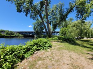
O’Sullivan’s Island is a peninsula at the confluence of the Housatonic and Naugatuck Rivers, located south of Derby’s downtown commercial district. While vehicles and trains pass nearby, the site offers a welcome moment of quiet among trees along the waterfront. Enveloped by structure, water, and sky, O’Sullivan’s Island is one of the most interesting and naturally beautiful pieces of land in the lower Naugatuck Valley. It is also one of the most challenging brownfield locations NVCOG has had the opportunity to improve.
Over the last decade, NVCOG’s Environmental Planner Arthur Bogen, Ricardo Rodriguez and Executive Director Rick Dunne have been significant players in the orchestration of funding contributions and work completed by the City of Derby and the Connecticut Department of Economic and Community Development. O’Sullivan’s Island Recreation Park opened to the public for the first time in over twenty years in 2009. In 2013 the City of Derby completed its portion of the Naugatuck River Greenway trail that runs across the site’s northern edge.
NVCOG was awarded a $200,000 DECD grant to conduct environmental assessments and develop (if needed) remediation strategies on the site. The U.S. Fish and Wildlife Service (USFWS) on behalf of the Connecticut Housatonic Natural Resource Trustee Council awarded NVCOG $325,000 to construct an accessible fishing and viewing platform at O’Sullivan’s Island Recreation Park.
Project Status: DECD – Phase I and Phase II Environmental Site Assessment complete. The handicapped-accessible fishing and viewing platform is now open to the public.