Members of NVCOG Staff are Published in the Latest Edition of Connecticut Planning Magazine

Connecticut Planning magazine cover Winter 2020

“If a picture is worth 1,00 words, then a map starts a whole conversation.”

Read “Story Maps as Conversations” in the latest issue of Connecticut Planning Magazine to learn how NVCOG uses interactive online maps to improve communication and engagement with the public. The article begins on page 6. The article was written by Richard Crowther Jr., GIS Analyst and Joanna Rogalski, Senior Regional Planner.


NVCOG CEOs Support Rail Line Legislation

NVCOG Mayors and First Selectman visited the State Capitol complex today in support of proposed legislation to improve rail service on the Waterbury Branch Line. A public hearing was held on Senate Bill 155, which would serve as the ‘vehicle’ legislation for the proposed upgrades.

Watch News 8’s video coverage here.

From left to right: Derby Mayor Richard Dziekan, State Sen. George Logan, R-17, Seymour First Selectman Kurt Miller, Ansonia Mayor David Cassetti, Naugatuck Mayor N. Warren “Pete” Hess, State Rep. Kara Rochelle, D-104, Speaker of the House of Representatives Joe Aresimowicz, Beacon Falls First Selectman Gerard Smith, Waterbury Mayor Neil O’Leary, State Rep. Larry Butler, D- 72, State Rep. Rosa Rebimbas, R-70, State Rep. Geraldo Reyes, D-75.


Municipal leaders and area state legislators, led by NVCOG Chairman, Waterbury Mayor Neil M. O’Leary addressed the media this morning prior to the Connecticut General Assembly’s Transportation Committee’s public hearing.


Testifying before the General Assembly’s Transportation Committee, left to right, State Rep. Rosa, Rebimbas, R-70, Naugatuck Mayor N. Warren “Pete” Hess and Waterbury Mayor Neil O’Leary. Also, in the second row, second from left, Thomaston First Selectman Ed Mone and, fourth from left, Derby Mayor Richard Dziekan.


DRAFT Naugatuck River Greenway Trail Routing Feasibility Study Report Published for Public Comment

The Naugatuck Valley Council of Governments (NVCOG) has published a draft report detailing the methods and findings of the Naugatuck River Greenway Trail Thomaston to Torrington Routing Feasibility Study. Public comments will be accepted at the project webpage through March 13th, 2020.

The project area detailed in the report spans approximately 11 miles of the Naugatuck Valley from Bogue Road in Torrington to a section of trail under design adjacent to the Water Pollution Control facility on Old Waterbury Road in Thomaston. The goals of the project, being conducted by BSC Group of Glastonbury, CT, were to catalogue existing conditions in the project corridor, inventory and assess all potential multiuse trail routes, identify a preferred route with input from stakeholders and the public, and develop conceptual designs, cost estimates and phasing recommendations to assist with future trail development.

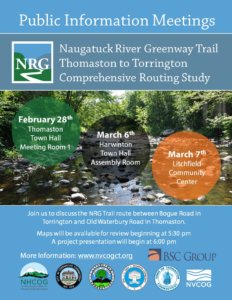
BSC and project partners inventoried all potential trail routes, including points of interest and environmental constraints along the way, and documented property ownership and stakeholder preferences and concerns. This information was used to narrow down prospective routes to those that were most feasible. Public input on various potential routing options was solicited at a series of public information meetings held in February and March 2019 in Harwinton, Litchfield and Torrington. Comments received at those meetings and during a public comment period that followed, helped refine and identify a preferred route that is presented in the report. The preferred route was selected by a project steering committee consisting of officials from the involved municipalities and other stakeholders.

Concerns regarding potential impact to the Off Highway Vehicle (OHV) area at the US Army Corps of Engineers (USACE) managed Thomaston Dam were well represented in public comments. The project team met several times with USACE staff and OHV representatives to address those issues. A compromise route was developed that avoids the OHV area to the greatest extent possible, and a trail concept along Old Route 8 was developed collaboratively between project partners, the USACE and OHV representatives that would safely separate motorized and non-motorized uses without negative impact to current OHV traffic flow.

Stakeholders were involved throughout the project including chief elected officials and staff from the municipalities of Torrington, Litchfield, Harwinton and Thomaston along with representatives from the US Army Corps of Engineers, NVCOG, NHCOG, the Naugatuck River Greenway Steering Committee, The Railroad Museum of New England, and several property owners along the route.

The NRG corridor has been officially designated as a greenway by the CT Greenways Council and the CT Department of Energy and Environmental Protection (DEEP). The entire NRG Trail is identified as a trail of statewide significance in the Connecticut Recreational Trails Plan, and was designated as one of 101 America’s Great Outdoors projects in 2011 by the U. S. Department of the Interior. An Economic Impact Study conducted by NVCOG in 2017 estimated that there would be substantial economic, health and community benefits of constructing the trail. The overall planned NRG trail route will follow the river for 44 miles, bringing it through parts of Torrington, Litchfield, Harwinton, Thomaston, Watertown, Waterbury, Naugatuck, Beacon Falls, Seymour, Ansonia and Derby. To date, trail sections have been constructed and are open to the public in Torrington, Watertown, Naugatuck, Beacon Falls, Seymour, Ansonia and Derby. Municipalities along the NRG Trail route are heading up the development of the trail locally, often funded with state and federal grants. For trail segments on federal land at Thomaston Dam, the USACE would be responsible for any trail development.

“The project team studied the corridor in detail, and worked hard to incorporate public and stakeholder desires and concerns in the preferred route and report,” said Bill Paille, Transportation Engineer at BSC Group. “The preferred route presented in the report is designed to meet each community’s long term goals and the information provided in the report will ensure that decisions made about NRG Trail development in the future will be well informed.”

The report includes information about the NRG Trail and the purpose of the study, along with a detailed explanation of the methods used by the project team. For each of seven corridor sections, it includes a description of existing conditions, summary of all routes investigated, and narrative and map of the preferred route. Cost estimates, phasing recommendations, and other pertinent information about the preferred route are presented, and a chapter about trail development considerations provides information to assist municipalities planning and developing trail sections in the future.

NVCOG, in partnership with the Northwest Hills Council of Governments (NHCOG), received a Responsible Growth and Transit Oriented Development grant from the Connecticut Office of Policy and Management (OPM) to conduct the study. The NVCOG and NHCOG are overseeing the project.

More information can be found, and comments can be submitted at:
https://nvcogct.gov/project/current-projects/naugatuck-river-greenway/nrg-thomaston-to-torrington-routing-study/

Public Meetings for the NRG Torrington to Thomaston Routing Study

Press Release

Contacts:
Aaron Budris

Naugatuck Valley Council of Governments

203-757-0535

abudris@nvcogct.org

Upcoming Meetings will Provide Opportunities for Public Input on Naugatuck River Greenway Trail Route

Harwinton, Litchfield, Thomaston and Torrington residents can review and provide feedback on prospective locations and plans for the Naugatuck River Greenway Trail during a series of upcoming public meetings. Project partners and community leaders will be on hand for the meetings, which will be held on February 28th at Thomaston Town Hall, March 6th at the Harwinton Town Hall, and March 7th at the Litchfield Community Center. All meetings will begin at 5:30 with an informal opportunity to view maps and talk to project staff. A formal presentation will begin at 6:00 pm and will be followed by a question and answer period and a review of specific comments with residents.

The public outreach follows more than one year of studying potential Naugatuck River Greenway Trail routing options between Torrington and Thomaston. The purpose of the NRG Torrington to Thomaston Comprehensive Routing Study, being conducted by BSC Group of Glastonbury, CT is to inventory potential routes and rank them with stakeholder and public input with the goal of selecting a final preferred route with broad consensus. BSC will also provide phasing recommendations and preliminary construction cost estimates of the preferred route to help municipalities plan for future construction and prepare for potential funding opportunities.

The Naugatuck Valley Council of Governments (NVCOG), in partnership with the Northwest Hills Council of Governments (NHCOG), received a Transit Oriented Development and Smart Growth grant from the Connecticut Office of Policy and Management (OPM) to conduct the study. The NVCOG and NHCOG are overseeing the project.

The project area spans approximately 11 miles of the Naugatuck Valley from Bogue Road in Torrington to a section of trail under design adjacent to the Water Pollution Control facility on Old Waterbury Road in Thomaston. During the past year, BSC and project partners inventoried all potential trail routes along with points of interest and environmental constraints along the way, and documented property ownership and stakeholder preferences and concerns. This information has been used to narrow down prospective routes to those that are most feasible. Now, public input is being solicited to help determine what route should ultimately be built when funding is secured.

Stakeholders have been involved throughout the project including chief elected officials and staff from the municipalities of Torrington, Litchfield, Harwinton and Thomaston along with representatives from the US Army Corps of Engineers, NVCOG, NHCOG, the Naugatuck River Greenway Steering Committee, The Railroad Museum of New England, and several property owners along the route.

The NRG corridor has been officially designated as a greenway by the CT Greenways Council and the CT Department of Energy and Environmental Protection (DEEP). The entire greenway trail is identified as a trail of statewide significance in the Connecticut Recreational Trails Plan, and was designated as one of 101 America’s Great Outdoors projects in 2011 by the U. S. Department of the Interior. An Economic Impact Study conducted by NVCOG in 2017 estimated that there would be substantial economic, health and community benefits of constructing the trail.

The overall planned NRG trail route will follow the river for 44 miles, bringing it through parts of Torrington, Litchfield, Harwinton, Thomaston, Watertown, Waterbury, Naugatuck, Beacon Falls, Seymour, Ansonia and Derby. To date, trail sections have been constructed in Torrington, Watertown, Naugatuck, Beacon Falls, Seymour, Ansonia and Derby. “We really want to hear what the public envisions for the NRG Trail,” said Bill Paille, Transportation Engineer at BSC Group. “We want to be sure that the preferred route meets each community’s long term needs and that the investments made are well-spent and provide the most benefit to residents.”

More information can be found on the study’s webpage.

Annual CFPZA Conference 2019

Apartment buildings in Shelton

The CFPZA annual conference will take place on Thursday, March 28, 2019 at the Aqua Turf in Southington, CT. The program for the Conference will include a presentation on Authority over Zoning Enforcement and recent attempts to transfer this power to First Selectman and Mayors. In addition, Length of Service awards will be presented to commission members. For more information, call 860-677-7355 or send an email to cfpza@live.com.

Public Notice – Metropolitan Mobility Network Meeting

The New York Metropolitan Transportation Council (NYMTC) announces the next meeting of its Metropolitan Mobility Network on Wednesday January 30, 2019 at 10 am. The meeting will be held at the NYMTC office in lower Manhattan. For security purposes, please RSVP to andrea.miles-cole@dot.ny.gov . Please note that the meeting also will be available remotely as a webinar using the following link at the time of the meeting:  https://meetny.webex.com/meetny/j.php?MTID=m8d20fe0ce32e263d55e9d6212c884701