Proposed Regional Wastewater Treatment Consolidation Would Save Local Taxpayers $66.5 Million, Lower Sewer Rates for Homeowners

Wastewater equipment in Seymour.

PRESS RELEASE

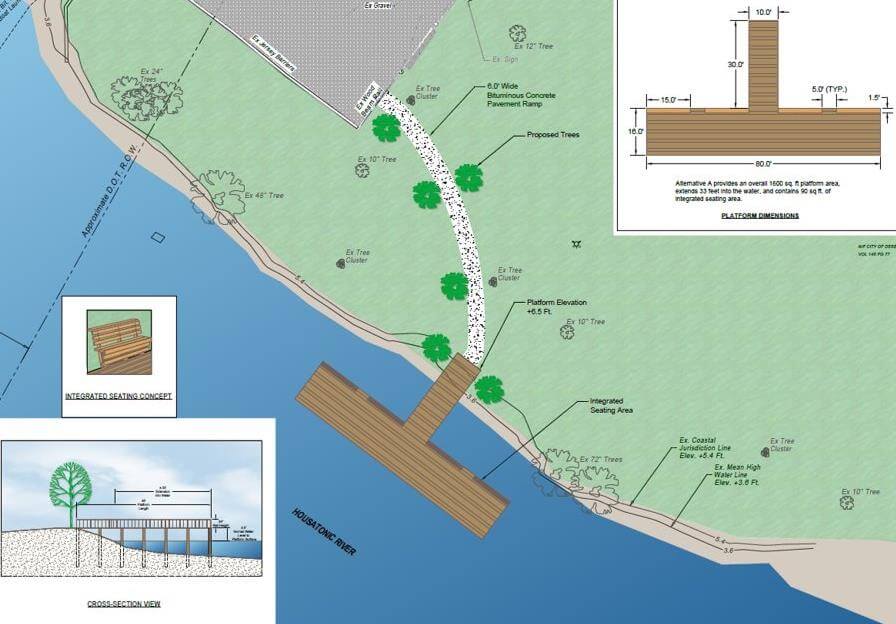
Regional Study Recommendations to be Presented in Public Meeting on Wednesday, January 26

Recommendations from the Naugatuck Valley Council of Governments (NVCOG) Regional Wastewater Treatment Consolidation Study will be presented to the public during a meeting at Ansonia High School, 20 Pulaski Hwy, Ansonia at 7 p.m. on Wednesday, January 26, 2022. The presentation will provide details of the projected $66.5 million in savings that would result for Seymour, Ansonia and Derby if the three towns regionalize wastewater treatment operations. Masks are required to be worn by participants inside Ansonia High School. Residents who want to log in virtually to participate in the meeting can do so via Zoom: https://tinyurl.com/NVCOG-Zoom

The public can also watch the presentation live on YouTube: https://tinyurl.com/NVCOG-YouTube

Funded primarily by a $1.35 million grant from the state Office of Policy and Management, the study began in April 2018. It provides a preliminary analysis of the region’s ability to increase capacity for properly treating wastewater in a consolidated facility or facilities, thereby leading to a reduction in long-term state and local capital improvements and a reduction of user fees. Study reports and findings can be found on the study’s webpage at: https://nvcogct.gov/project/current-projects/regional-wastewater-treatment-consolidation-study/

Should the three municipalities choose to move forward in consolidating wastewater treatment operations, they would form a regional entity to oversee a shared treatment facility and wastewater collection systems, set rates and decide the most economical way to operate the system. The three communities would need to take an active role in pursuing the savings via the creation and support for the regional entity. An underlying assumption to the study is that the long-term savings from consolidating the systems would be passed on to ratepayers.

The study features two components, an Engineering Component conducted by Black & Veatch Inc, of Overland Park, Kansas (Black & Veatch) and an Economic Analysis & Governance component conducted by the Edward J. Collins Center for Public Management, UMASS, Boston (The Collins Center).

According to Black & Veatch, the most important conclusion from this detailed and extensive study is that regionalization of these wastewater systems is more cost effective long-term than the current scenarios of maintaining separate wastewater treatment. Also of critical importance is that the recommended regional alternative provides more environmental benefit than any of the other alternatives studied.

During the January 26 informational presentation, residents will have the opportunity to learn how the study was conducted, methods used to collect data and how findings were derived. Recommendations for an organizational structure, bylaws and representation for a regional wastewater treatment authority, per the State of Connecticut’s model legislation, will also be detailed.

The study’s Phase I analyzed the wastewater treatment operations in Ansonia, Beacon Falls, Derby, Naugatuck and Seymour for consolidation potential and corresponding savings. It produced 23 possible consolidation alternatives. Phase I findings were presented to the legislative bodies of each municipality in April and May of 2019.

Phase II began in March 2020 and refined the list to a final preferred alternative presented to stakeholders in a June 2021 workshop. Savings projections were refined in the following months and presented to stakeholders during a November 9 workshop.

The following is a study timeline and potential next steps in utilizing its findings:

April 2018: NVCOG executes a contract with Black & Veatch to conduct Phase I of the study’s Engineering Component. Analysis begins of wastewater treatment plants in the municipalities of Ansonia, Beacon Falls, Derby, Naugatuck and Seymour for potential consolidation and/or the sharing of services. Tasks include a review of existing planning documents and assessments of current facilities and collection system infrastructures.

March 2019: Phase I concludes. Black & Veatch and NVCOG staff present findings to the legislative bodies of the five municipalities in April and May.

March 2020: Phase II commences a more extensive technical and engineering analysis, as well as identification of a short list of alternatives and preferred alternative(s) to the systems currently in place.

May 2020: The study’s Economic Analysis & Governance Component begins, conducted the Collins Center. This component will analyze capital and operating and maintenance (O&M) costs of the currently separate facilities (base case) for each jurisdiction that will be included with the preferred alternative regional wastewater system(s). It will also recommend a governance model(s) for the preferred alternative regional wastewater system(s), including draft by-laws for the representation model and wholesale rate-setting procedures.

June 2021: Black & Veatch presents its final preferred alternative in a regional stakeholder workshop. The proposal would merge the wastewater treatment operations of the Cities of Ansonia and Derby and Town of Seymour at one plant, located at the site of the current Ansonia facility.

January 2022: Black & Veatch and The Collins Center present study findings and recommendations to the general public during a public meeting at Ansonia High School.

To achieve wastewater regionalization, recommended ‘Next Steps’ would involve establishing a wastewater consolidation committee with representatives from each municipality that has independent legal representation. The committee would then move forward with the following actions:

Step 1: Finalize cost allocation methodology

  • Negotiate a cost allocation methodology which will require further financial modeling
  • Hire asset valuation consultant to assess existing value of infrastructure (either through NVCOG facilitation or via an inter-municipal agreement) Incorporate the cost allocation scheme into a separate legal agreement or the proposed Sewer Ordinance and Bylaws establishing and defining a proposed Naugatuck Valley Wastewater Pollution Control Authority.

Step 2: Finalize all legal foundational documents

  • Vet the cost allocation agreement, ordinance, and bylaws with legal counsel, DEEP, and other stakeholders
  • Develop the preliminary plan of operation (either through NVCOG facilitation or via an inter-municipal agreement)
  • Legislative bodies adopt cost allocation agreement, ordinance, and bylaws after preferred public engagement process
  •  Receive approval of the ordinance and preliminary plan of operation from DEEP Commissioner and State Treasurer

Step 3: Implement the regional WPCA

  • Appoint Directors to regional WPCA Board of Directors

Note: All future steps the responsibility of the Board consistent with the legal foundational documents and the preliminary plan of operation.

Contact:

Desira Blanchard
Naugatuck Valley Council of Governments
203-489-0353
dblanchard@nvcogct.org

NVCOG and Environmental Partners Take Legal Action on Kinneytown Dam

Kinneytown Dam

PRESS RELEASE

Waterbury, Conn. – The Kinneytown Dam, owned by Hydroland Corporation, has blocked migratory fish passage on the Naugatuck River for long enough. Today the Naugatuck Valley Council of Governments (NVCOG), comprised of the 19 municipalities surrounding the Naugatuck River, along with environmental organizations Save the Sound and Naugatuck River Revival Group (NRRG), have jointly taken legal action at the Federal Energy Regulatory Commission (FERC), aimed at restoring the once thriving sea-run fisheries of the Naugatuck River. The legal filing by NVCOG, Save the Sound, and NRRG asks FERC to revoke Hydroland’s operating license exemption.

“Hydroland has ignored their responsibility to manage and maintain Kinneytown Dam for too long, and they do not deserve the license exemption they have,” said Mayor Pete Hess of Naugatuck. “We won’t tolerate a facility that damages the environment and is unsafe in our communities any longer.”

“Let’s face it, these generating plants have been off-line for some time—one for more than a decade. Without the generation of power, we need to question the role played by this abandoned facility that damages our restored river,” Mayor Neil O’Leary of Waterbury added. “We are asking FERC to take more direct action against this operator. We have to find a way for fish to migrate past this obstruction on the Naugatuck River so that we can finally realize all of the benefits of the public investments made by Connecticut taxpayers, our partner river towns, and the many activists in restoring the Naugatuck River over the past decades.”

Longstanding and severe problems with fish passage conditions and actual passage of individual species at the dam have been detailed in multiple studies previously submitted to FERC. These longstanding problems include failure to control spill coming over the dam, a fish ladder that was not constructed as designed and is not being operated as required, and an unauthorized shutdown of one of the operating turbines.

“For many years, including 2021, the dam has served as an almost complete barrier to thousands of fish, including American shad and river herring, that are coming into the river from Long Island Sound and attempting to spawn upstream,” said Kevin Zak, founder of Naugatuck River Revival Group. “The fish ladder is a failure, and it has been since it was built. Little has been done to remedy this situation for the past 20 years, and recent efforts by the agencies have been met with radio silence by dam owner Hydroland. Clearly something more must be done.”

In November 2020, and again in July 2021, Save the Sound and NRRG submitted photographic and video documentation to FERC demonstrating the presence of hundreds of migratory fish below the dam, and showing their inability to pass the dam during the upstream migration that occurs each spring. Then, in September, a team of experts from Save the Sound, NRRG, and Queens College, CUNY, submitted to FERC an analysis, based upon two decades of Connecticut Department of Energy and Environmental Protection (CT DEEP) data gathered at the dam site, showing that favorable water flows for fish passage at the dam occur only during 39 percent of the peak fish passage period in the average year due to operational and structural conditions. Some years have little or no favorable flows for the entire spring fish run, resulting in extremely low passage rates.

The impacts from this situation are dramatic: from 2000 to 2020, the average number of fish passing Kinneytown Dam annually for three target species for restoration—American shad, blueback herring, and alewife—was 12.5 individual fish combined from April 1 to July 1—a fraction of a percentage of the original restoration goals of more than 22,000 shad and 220,000 river herring (blueback herring and alewife) expected to be counted annually.

Over the last several months, FERC, which is responsible for licensing the dam and overseeing its operations, has ordered Hydroland to explain this situation and to comply with directives from state and federal resource agencies. To date, Hydroland has failed to respond, missing all filing deadlines required by FERC, and has taken no required actions onsite. FERC has also cited multiple safety concerns related to the site.

Save the Sound staff attorney Kat Fiedler stated, “Hydroland is in violation of numerous fundamental conditions of its operating license exemption, including improperly constructed facilities, changes to operations, and decades of neglect and deterioration allowed by previous dam owners and now Hydroland. Even with renewed attention to this issue by the federal agencies, deadlines to address this situation set by those agencies have been completely ignored, continuing this history of complete disregard for the environmental harm caused by this dam. Our legal action asks FERC to exercise its authority revoke the current exemption.”

Among other relief, today’s filing by NVCOG, Save the Sound, and NRRG asks that:

A. FERC declare the Kinneytown fish passage operations out of compliance with its exemption.

B. FERC revoke the current exemption and require the owner apply for a new exemption or license, and that any new application include designs, based on best available engineering and science, for safe, timely, and effective fish passage.

NVCOG, Save the Sound, and NRRG are members of the Naugatuck River Restoration Coalition, a group of municipalities and environmental organizations working to restore the Naugatuck River. Conditions at Kinneytown Dam have also been noted by Senator Richard Blumenthal, Senator Chris Murphy, and Congresswoman Rosa DeLauro, who have called for action to restore effective fish passage on the Naugatuck River.

###

Previous filings and orders:

NVCOG is represented by Attorney Ronald A. Shems of Tarrant, Gillies & Shems in Montpelier, VT. Ron practices energy and environmental law before federal courts and agencies and in several states. Tarrant, Gillies & Shems represents individuals, municipalities, businesses, regulated industries, cooperatives, and non-profit corporations. www.tarrantgillies.com

Public Information Meeting: O’Sullivan’s Island Fishing Pier Project

Derby Fishing Platform

Public Information Meeting:  O’Sullivan’s Island Fishing Pier Project

NVCOG held a public information meeting for the O’Sullivan’s Island Fishing Pier project on Tuesday, September 28th at 5:30 p.m. in the Aldermanic Chamber at Derby City Hall (1 Elizabeth Street). The project involves the construction of an accessible observation platform and a fishing pier extending into the Housatonic River. A recording of this meeting is available to watch on the NVCOG YouTube Channel.

O'Sullivan's Island Viewing & Fishing Platform Sketch

For any questions concerning the project, please contact Christine O’Neill, Environmental Planner, coneill@nvcogct.gov.

Information Meeting Scheduled for the NVCOG Natural Hazard Mitigation Plan

The public is invited to hear about and comment on the development of a multi-jurisdictional Natural Hazard Mitigation Plan (NHMP) for the NVCOG Region at a virtual August 4th public information meeting at 6pm. At this public meeting, the project consultants will update the public on progress and present draft recommendations. Details about the project and a link to register for the virtual meeting can be found on the project webpage at www.nvcogct.gov/hmp .

NVCOG Staff and our consultant SLR (formerly Milone and MacBroom) have been working on a multijurisdictional Regional Natural Hazard Mitigation Plan (NHMP) over the past year. The plan, funded with a grant from FEMA, will update municipal NHMPs and develop a consolidated multijurisdictional plan for the entire Naugatuck Valley planning region in compliance with FEMA standards and requirements that will serve as the approved NHMP for each NVCOG municipality.  The draft 2021 NVCOG NHMP identifies natural hazards and risks, existing capabilities, and activities that can be undertaken by each community to prevent loss of life and reduce property damages associated with the identified hazards. Public safety and property loss reduction are the driving forces behind this plan.

The project team has worked with local coordinators (who served as local points of contact for the NHMP), municipal staff and stakeholders from each community to review previous plans and identify natural hazards and risks, existing capabilities, and activities that can be undertaken by a community to prevent loss of life and reduce property damages associated with the identified hazards. Information about natural hazards and potential mitigation measures was shared with the public through several municipal and public workshops and with an informational storymap. Input from municipal officials, stakeholders and the public has been incorporated into the draft report.

The draft report will be submitted first to CT DEMHS, then to FEMA for review and approval. Once approved, municipalities will adopt the plan individually, likely this fall.


Draft Oxford Route 67 Alternative Transportation Plan Report Published

The public is invited to review and provide feedback on a Draft Oxford Route 67 Alternative Transportation Study Report.  The Draft report presents the existing conditions in the corridor along with recommendations for bicycle, pedestrian, and transit improvements. Comments can be submitted until August 15th, 2021.  The report and more information can be found on the project webpage at www.nvcogct.gov/oxfordroute67 .

The Oxford Main Street Alternative Transportation Study has been underway since December 2019, investigating the potential for non-motorized transportation alternatives and transit in the Route 67 corridor between Seymour and Southford. Study partners collected and analyzed information about the existing conditions in the corridor, collected input from stakeholders and the public, and investigated potential bicycle, pedestrian, and transit improvements. The focus is to improve connections and transportation options to the Seymour sidewalk network, train station and Naugatuck River Greenway Trail to the south, and the Larkin Bridle Trail to the north, as well as to all the businesses, services, green spaces, and residential areas within the corridor. The potential for transit service was also investigated, focusing on connections to services and major residential and commercial centers and to surrounding communities.

The Oxford Main Street Project Committee is overseeing the project, and it builds on previous work the committee has undertaken to improve access to the Little River and natural resources along Route 67. The goal is to provide better access to the businesses and natural resources throughout the corridor. The final report will provide a cohesive plan for the entire corridor to better enable the Town to plan, prioritize, and fund future improvements. The Naugatuck Valley Council of Governments (NVCOG) is funding the project with federal transportation planning funds. TranSystems Corporation, a planning and engineering consultant with offices in Meriden, CT is the project consultant. A final report, incorporating comments from stakeholders and the public, will be published this summer.

Oxford’s Plan of Conservation and Development prioritized creating more of a downtown feel along Route 67. Unlike many of its neighbors, Oxford does not have a typical walkable New England downtown or Main Street.

Instead, municipal and commercial areas are dispersed along with residences along State Route 67. While Route 67 fundamentally functions as Oxford’s “Main Street,” it currently has no sidewalks or safe bicycle or pedestrian access. In addition, there is currently no public transit currently operated along Route 67 providing residents an alternative transportation option. Transit options by train on Metro North and by bus on CT Transit are available only one mile from the Oxford town line, but there is currently no way for Oxford residents to safely access these services without a personal motor vehicle.

Oxford First Selectman George Temple explained that “Oxford residents have voiced support for pedestrian and bicycle access along the Little River and Route 67. This study allows us to make progress toward that goal, and to give the public a chance to help guide and contribute to future efforts”.

TranSystems Project Manager Casey Hardin said that “This is the time for area residents to provide input on the planning for this important municipal resource. The study includes recommendations to improve mobility options for bicyclists and pedestrians, as well as folks who would like options beyond their automobile”.

Public Information Meeting Scheduled for the Oxford Route 67 Alternative Transportation Plan

Oxford residents and business owners are invited to review and provide feedback on a Draft Oxford Route 67 Alternative Transportation Study report during a Public Information Meeting on June 17th, 2021, beginning at 6:30 p.m. in the Oxford High School auditorium.  The Draft report presents the existing conditions in the corridor along with recommendations for bicycle, pedestrian, and transit improvements. Project partners will present the draft plan and be available to take comments and answer questions at the June 17 meeting. An alternative virtual broadcast of the presentation will be available for those unable to attend in person.  The draft report and meeting details can be found on the study webpage at www.nvcogct.gov/oxfordroute67.

The Oxford Main Street Alternative Transportation Study has been underway since December 2019, investigating the potential for non-motorized transportation alternatives and transit in the Route 67 corridor between Seymour and Southford. Study partners collected and analyzed information about the existing conditions in the corridor, collected input from stakeholders and the public, and investigated potential bicycle, pedestrian, and transit improvements. The focus is to improve connections and transportation options to the Seymour sidewalk network, train station and Naugatuck River Greenway Trail to the south, and the Larkin Bridle Trail to the north, as well as to all the businesses, services, green spaces, and residential areas within the corridor.  The potential for transit service was also investigated, focusing on connections to services and major residential and commercial centers and to surrounding communities.

The Oxford Main Street Project Committee is overseeing the project, and it builds on previous work the committee has undertaken to improve access to the Little River and natural resources along Route 67. The goal is to provide better access to the businesses and natural resources throughout the corridor.  The final report will provide a cohesive plan for the entire corridor to better enable the Town to plan, prioritize, and fund future improvements. The Naugatuck Valley Council of Governments (NVCOG) is funding the project with federal transportation planning funds.  TranSystems Corporation, a planning and engineering consultant with offices in Meriden, CT is the project consultant.  A final report, incorporating comments from stakeholders and the public, will be published this summer.

Oxford’s Plan of Conservation and Development prioritized creating more of a downtown feel along Route 67. Unlike many of its neighbors, Oxford does not have a typical walkable New England downtown or Main Street.

Instead, municipal and commercial areas are dispersed along with residences along State Route 67. While Route 67 fundamentally functions as Oxford’s “Main Street,” it currently has no sidewalks or safe bicycle or pedestrian access.  In addition, there is currently no public transit currently operated along Route 67 providing residents an alternative transportation option.  Transit options by train on Metro North and by bus on CT Transit are available only one mile from the Oxford town line, but there is currently no way for Oxford residents to safely access these services without a personal motor vehicle.

Oxford First Selectman George Temple explained that “Oxford residents have voiced support for pedestrian and bicycle access along the Little River and Route 67. This study allows us to make progress toward that goal, and to give the public a chance to help guide and contribute to future efforts”.

TranSystems Project Manager Casey Hardin said that “This is the time for area residents to provide input on the planning for this important municipal resource. The study includes recommendations to improve mobility options for bicyclists and pedestrians, as well as folks who would like options beyond their automobile”.

PUBLIC NOTICE – MAP Forum Spring Web Meeting, June 10, 2021

Map of MAP Forum
Map of MAP Forum

The Metropolitan Area Planning (MAP) Forum announces its 2021 Spring Meeting on Thursday June 10, 2021 at 10:30 am. Due to the current public health emergency, this meeting will be held as a web meeting and will be hosted by the Lehigh Valley Planning Commission.

To register, please RSVP via Eventbrite at https://www.eventbrite.com/e/2021-spring-web-meeting-of-the-metropolitan-area-planning-map-forum-tickets-157240678101 The meeting agenda appears below.

Agenda

Kick-Off Meeting for the West Main Street Corridor Study in Waterbury

Road work ahead sign

On behalf of the City of Waterbury, the Naugatuck Valley Council of Governments is conducting a virtual public workshop to discuss improvements that are needed to West Main Street in Waterbury between Route 8 and the Green. Please join us for an online discussion to learn about the goals and objectives of the West Main Street Corridor Study and to share your thoughts on how traffic, walking, biking, and bus access can be improved along the corridor.

Register to participate in the meeting at https://register.gotowebinar.com/register/6871735879652304143
Or join by audio by dialing 1-631-992-3221 and access code 942-927-244

Currently, we are in the “Existing Conditions” phase of the project, collecting data and input to learn as much as we can about the challenges and opportunities of this corridor.


Public Information Meeting for Spot Improvements Route 67 in Seymour

Road work ahead sign

For Immediate Release: October 30, 2020
Updated: November 19, 2020
 

Contacts: 
Mark Nielsen
Naugatuck Valley Council of Governments
(203) 757-0535
mnielsen@nvcogct.gov   


VIRTUAL PUBLIC INFORMATION MEETING 

STATE PROJECT NO. 124-165 

 ROUTE 67(BANK STREET) SPOT IMPROVEMENTS 

SEYMOUR, CONNECTICUT
MONDAY, NOVEMBER 16, 2020 


The Naugatuck Valley Council of Governments (NVCOG) held a virtual public information meeting to present preliminary design plans on Spot Improvements to Route 67 (Bank Street), in The Town of Seymour. The public meeting was held on Monday, November 16, 2020. The meeting was held online via Zoom beginning at 6 pm. The intent of the meeting was to provide residents and other interested persons an opportunity to learn about the design and proposed improvements and understand the project timeline. A presentation was made, after which there was a question and answer period.  To view the recording of this meeting and review the presentation, please visit the Route 67 (Bank St) Spot Improvements project webpage.

It is NVCOG’s and the State’s policy to keep persons informed about and involved with ongoing road improvement projects. It is important that the community share its concerns to assist in the project’s development.  

 The intent of the project is to improve traffic, pedestrian flow, and safety along the section of Route 67 (Bank Street) between River Street/Franklin Street and Klarides Village and is a continuation of the planning effort completed in 2017. The firm of Milone and MacBroom is designing the improvements under contract to the NVCOG. Construction will be advertised and administrated by the Connecticut Department of Transportation (CTDOT).  The project will include: 

Route 67 and River Street/Franklin Street Intersection 
Improve pedestrian crossings 
Widen northbound River Street approach to extend the left-turn lane onto Route 67
Make sidewalk connection from River Street to the south side of Route 67 

Route 67 between River Street/Franklin Street Intersection and Old Drive East
Widen Route 67 to provide adequate storage on northbound and southbound dedicated turn lanes and 5-foot shoulders
Widen north side of Route 67 to extend the two westbound departure lanes past Martha Street to the Walgreens Intersection.
Reconstruct stone masonry retaining wall at 100 Bank Street.
Construct new retaining wall between Martha Street and Walgreen’s driveway.
Install new traffic signal equipment.
Install new sidewalks, pedestrian accommodations, and lighting. 

 Route 67 at Walgreens Driveway
Widen Route 67 to provide a westbound dedicated right and extended right turn lane in addition to the single through lane.
Upgrade traffic signal to accommodate geometric changes at the intersection.
Implement revised signal timings. 

 Route 67 at Old Drive West
Upgrade the existing traffic signal with new pedestrian equipment.
Revised phasing to include an exclusive pedestrian phase. 

Route 67 at Klarides Village Unsignalized
Add westbound left turn lane into the driveway.
Modify driveway to prohibit left turns onto Route 67. 

 Route 67 at Beecher Street and Church Street
Reconfigure the intersection to better direct and channelize the turning movements. 

 Route 313 (River Street)
Widen River Street to provide additional storage and queuing lengths for the northbound travel lanes.
Widen bridge over Little River to provide a new sidewalk along the western side of River Street connecting to the existing Route 67 sidewalks. 

 Additional Traffic Signal Timing Improvements
Timing improvements throughout the corridor. 

Improve Pedestrian Connection to Downtown
Improve lighting and hardscape under Route 8.

Based on the preliminary design, the construction cost will be approximately $6,100,000. The Federal Highway Administration will provide 80% of the construction cost with the State providing 20%. 

The public informational meeting was held to afford an opportunity for public participation and allow open discussion of any views and comments the community may have concerning this proposed project. 

 Persons with limited internet access may request project information be mailed to them by calling  (203489-0369 or emailing  mnielsen@nvcogct.gov(Allow one week for processing and delivery.) 

 There will be a 14day comment period following the meeting.  Individuals may leave a question or comment via email/phone at ksvetz@nvcogct.gov and (203) 489-0374.

NVCOG Developing Regional Natural Hazard Mitigation Plan

For Immediate Release: October 26, 2020

Naugatuck Valley Council of Governments Seeking Input on Regional Hazard Mitigation Plan

Virtual Workshop Scheduled for November 18


The Naugatuck Valley Council of Governments (NVCOG) recently received a Pre-disaster Hazard Mitigation Planning grant from the Federal Emergency Management Agency (FEMA) to prepare a regional, multi-jurisdiction Natural Hazard Mitigation Plan (HMP) that will update plans in all 19 municipalities in its planning region. The project team will hold virtual public workshops where attendees can learn about hazard mitigation planning, possible risks they face from a natural hazard, and speak directly with the consultants developing the HMP update. The study team also wants to hear from residents about their concerns and opinions. The first public workshop is scheduled for November 18, 2020 at 5:30 PM.

A Natural Hazard Mitigation Plan (HMP) is a tool that helps a community to understand risk and to take specific steps to reduce property damage, injury, and loss of life from natural disasters, such as Tropical Storm Isaias. The November 18 workshop will provide details on the hazards being addressed in the plan, the risks they pose, and the types of losses that can occur to life and property in the Naugatuck Valley region. Details of how to participate in the workshop are available at www.nvcogct.gov/HMP.

Public engagement is critical to the planning process, and a short online survey is also available for members of the public to provide information to project staff. The survey should take less than 10 minutes to complete and can be found on the project webpage. While the ongoing pandemic will limit typical public engagement forums, such as public meetings and in-person workshops, the webpage, survey and workshop provide key opportunities for residents to learn about the project and provide feedback.

A FEMA-approved Hazard Mitigation Plan is required for a municipality to be eligible for certain hazard mitigation grant funding. An approved HMP is not required, however, for a community to be eligible for relief funding after an event has occurred. The HMP helps public officials and residents understand vulnerabilities and will identify actions that communities can take to prevent or minimize future risk.

NVCOG and project consultant Milone & MacBroom, Inc. of Cheshire will be working with all 19 regional municipalities over the next year to develop the multi-jurisdictional HMP. Developing a multi-jurisdictional plan is a more cost-effective approach than each community creating its own HMP. However, understanding that each community is unique and has its own specific risks, hazards specific to each municipality will be addressed in separate municipal sections in the regional plan. The plan will take recent major events into account and will investigate risks from floods, winter storms, tornadoes, hurricanes, wildfires, earthquakes, and dam failure, among others. The HMP will also identify activities that can be undertaken by each community to prevent loss of life and reduce property damages associated with the identified hazards. Public safety and property loss reduction are the driving forces behind this plan, but careful consideration will also be given to the preservation of history, culture and the natural environment of the region.

Future virtual public meetings will focus on specific communities in the region. Stay tuned for dates and times!

Please visit www.nvcogct.gov/HMP for more details.

Contacts:
Aaron Budris
Naugatuck Valley Council of Governments
203-757-0535
abudris@nvcogct.org