The Connecticut Department of Transportation (CTDOT) has launched the New Mix program’s website which can be viewed at https://www.newmixwaterbury.com/.
The New Mix is CTDOT’s program dedicated to planning for the long-term future of the Interstate 84/Route 8 interchange in Waterbury, Connecticut, also known as the “Mixmaster.”
On the New Mix website, you will be able to learn about the very early planning process for the New Mix program. As the New Mix program progresses, the website will be updated to keep you informed. The website also features a form for questions and comments: https://bit.ly/NewMixComments!
Total of more than $714K in grant funding will help build coastal and riverine resilience for wildlife and communities.
NEW HAVEN, CONN – Save the Sound has been awarded two grants from the Long Island Sound Futures Fund (LISFF), administered by the National Fish and Wildlife Foundation (NFWF). The funds awarded consist of $109,618 to produce Road-Stream Crossing Management Plans (RSCMPs) for three towns in the Naugatuck Valley, and $604,461 to construct the first phase of a wetland restoration and living shoreline project in Queens, NY. Both awards were publicly announced at a December 6 virtual press event hosted by the Long Island Sound Study that featured remarks by federal and state environmental agencies, and statements from Senator Richard Blumenthal (CT), Senator Chris Murphy (CT), and three of the co-chairs of the Long Island Sound Congressional Caucus: Representative Joe Courtney (CT), Representative Lee Zeldin (NY) and Representative Thomas Suozzi (NY).
The LISFF, which is funded by the EPA through the Long Island Sound Study (LISS), granted a total of $5.4 million to local governments, universities, and community organizations across Connecticut, New York, and Vermont this year. The focus of the fund is projects that will improve water quality and restore habitat in the Long Island Sound watershed.
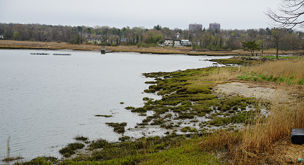
Eroded shoreline in Udalls Cove, Little Neck Bay, Queens, NY.
Big Rock Wetland Restoration in Queens
The $604,461 award from the Futures Fund will fund construction of the first phase of a community-driven wetland restoration project in Little Neck Bay, Queens designed to address the effects of erosion, historical fill, and poor water quality in Udalls Cove. During the first phase, the project team will restore degraded shoreline along Memorial Field by installing 600 linear feet of oyster castles and planting native coastal species. This will restore one acre of native salt marsh and oyster habitat, while creating the conditions for marsh migration in an urban environment.
“We’re thrilled to receive this award to help bring the community’s vision to reality, using nature-based solutions to help address the serious erosion and marsh loss in this section of Little Neck Bay,” said Katie Friedman, NY ecological restoration program manager for Save the Sound. “New York City has lost more than 85 percent of its tidal marshes in the past century, and with climate change accelerating there is a clear urgency to act on bold, community-driven, nature-based solutions like the Big Rock Wetland Restoration project.”
Save the Sound will be partnering with community groups—the Douglas Manor Association (DMA) and the Douglas Manor Environmental Association (DMEA) in particular—as well as other local groups such as the Udalls Cove Preservation Committee to complete this project and engage area residents and students in the work. Phase one of the Big Rock Wetland Restoration project will be completed in parallel with complementary work by the NYC Department of Parks and Recreation in the Alley Creek area of Little Neck Bay.
“The Big Rock Wetland Restoration Project began more than eight years ago as a dream to restore this degraded wetland—and it has evolved to become a community partnership with many neighborhood organizations and local schools deeply involved,” said DMEA board member Jamie Sutherland, who co-chairs the Big Rock Wetland Restoration Project Committee. “The Douglas Manor Environmental Association is absolutely thrilled to be receiving this funding and beginning Phase I of construction with our partner, Save the Sound.”
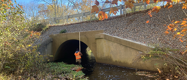
Save the Sound’s Jon Vander Werff taking culvert measurements at a road-stream crossing.
Road-Stream Crossing Management Plans in the Naugatuck Valley
Using the awarded funds and matching contributions, Save the Sound will work with the Housatonic Valley Association (HVA) and the Naugatuck Valley Council of Governments (NVCOG) to assess all road-stream crossings (e.g., culverts and bridges) in Prospect, Bethany, and Thomaston.
“Anywhere a waterway meets a roadway, there is the potential for damage to either system and the species that depend on it,” said Jon Vander Werff, fish biologist for Save the Sound. “Though it’s far less visible to our eyes, rivers and streams are coursing with life that depends on their uninterrupted flow, just as we rely on accessible, barrier-free roadways for everything from errands to emergency evacuations.”
Following protocols established by the North Atlantic Aquatic Connectivity Collaborative (NAACC), the team will collect data used to assess how much of a barrier each culvert and bridge poses to the passage of fish and other aquatic wildlife. Further data collected at each site will be used by UCONN to assess the flood resilience of each structure within the context of climate change, which is expected to bring more frequent extreme rain events and flooding to the Northeast.
Working with municipal staff, the project team will identify priority road-stream crossings for replacement in each town, and compile the results of the NAACC and UCONN analyses in RSCMPs presented to town officials and NVCOG. The project will build upon past assessment and planning efforts by both HVA and NVCOG in the Naugatuck Valley, as well as the decades of work to restore water quality and passage for fish, wildlife, and communities along the Naugatuck River.
First Selectman Ed Mone of Thomaston added: “The work that will be done by Save the Sound by virtue of receiving this grant will go a long way in assisting Thomaston by identifying the long-term sustainability of our road/stream crossings, while also ensuring the safe passage of aquatic wildlife that lives and thrives in those waterways.”
“This project links short- and long-term infrastructure planning with preserving the ecological functions of our watercourses,” said NVCOG Executive Director Rick Dunne. “The information gathered from these studies will empower municipal decision-makers to allocate resources in a way that best serves the community and environment.”
Other Awards
In addition to these two awards, Save the Sound also partnered on several other applications to the Long Island Sound Futures Fund this year. Among those funded were a project led by The Nature Conservancy to site and design bioswales in Bridgeport, CT; a proposal led by Cornell Cooperative Extension of Suffolk County to remove derelict lobster pots from Long Island Sound; and a proposal by City Island Oyster Reef to complete designs and permitting for two oyster reefs in City Island, Bronx, NY.
Save the Sound protects and improves the land, air, and water of Connecticut and Long Island Sound. We use legal and scientific expertise to bring people together and achieve results that benefit our environment for current and future generations. Our vision is of a Connecticut and Sound region where the vitality of nature will be protected for people and wildlife, now and for many decades to come. A region in which citizens from all walks of life can unite in transforming struggling habitats, polluted waters, endangered wildlife, and a threatened planet into resilient, healthy, vibrant, and inspiring places that sustain communities. View our organizational impact and ongoing projects at www.savethesound.org/impactmap.
Chartered by Congress in 1984, the National Fish and Wildlife Foundation (NFWF) protects and restores the nation’s fish, wildlife, plants and habitats. Working with federal, corporate and individual partners, NFWF has funded more than 5,000 organizations and generated a conservation impact of $6.8 billion. Learn more at www.nfwf.org.
The Long Island Sound Study, developed under the EPA’s National Estuary Program, is a cooperative effort between the EPA and the states of Connecticut and New York to protect and restore the Sound and its ecosystem. To learn more about the Long Island Sound Study, visit www.longislandsoundstudy.net.
Waterbury, Conn. – The Kinneytown Dam, owned by Hydroland Corporation, has blocked migratory fish passage on the Naugatuck River for long enough. Today the Naugatuck Valley Council of Governments (NVCOG), comprised of the 19 municipalities surrounding the Naugatuck River, along with environmental organizations Save the Sound and Naugatuck River Revival Group (NRRG), have jointly taken legal action at the Federal Energy Regulatory Commission (FERC), aimed at restoring the once thriving sea-run fisheries of the Naugatuck River. The legal filing by NVCOG, Save the Sound, and NRRG asks FERC to revoke Hydroland’s operating license exemption.
“Hydroland has ignored their responsibility to manage and maintain Kinneytown Dam for too long, and they do not deserve the license exemption they have,” said Mayor Pete Hess of Naugatuck. “We won’t tolerate a facility that damages the environment and is unsafe in our communities any longer.”
“Let’s face it, these generating plants have been off-line for some time—one for more than a decade. Without the generation of power, we need to question the role played by this abandoned facility that damages our restored river,” Mayor Neil O’Leary of Waterbury added. “We are asking FERC to take more direct action against this operator. We have to find a way for fish to migrate past this obstruction on the Naugatuck River so that we can finally realize all of the benefits of the public investments made by Connecticut taxpayers, our partner river towns, and the many activists in restoring the Naugatuck River over the past decades.”
Longstanding and severe problems with fish passage conditions and actual passage of individual species at the dam have been detailed in multiple studies previously submitted to FERC. These longstanding problems include failure to control spill coming over the dam, a fish ladder that was not constructed as designed and is not being operated as required, and an unauthorized shutdown of one of the operating turbines.
“For many years, including 2021, the dam has served as an almost complete barrier to thousands of fish, including American shad and river herring, that are coming into the river from Long Island Sound and attempting to spawn upstream,” said Kevin Zak, founder of Naugatuck River Revival Group. “The fish ladder is a failure, and it has been since it was built. Little has been done to remedy this situation for the past 20 years, and recent efforts by the agencies have been met with radio silence by dam owner Hydroland. Clearly something more must be done.”
In November 2020, and again in July 2021, Save the Sound and NRRG submitted photographic and video documentation to FERC demonstrating the presence of hundreds of migratory fish below the dam, and showing their inability to pass the dam during the upstream migration that occurs each spring. Then, in September, a team of experts from Save the Sound, NRRG, and Queens College, CUNY, submitted to FERC an analysis, based upon two decades of Connecticut Department of Energy and Environmental Protection (CT DEEP) data gathered at the dam site, showing that favorable water flows for fish passage at the dam occur only during 39 percent of the peak fish passage period in the average year due to operational and structural conditions. Some years have little or no favorable flows for the entire spring fish run, resulting in extremely low passage rates.
The impacts from this situation are dramatic: from 2000 to 2020, the average number of fish passing Kinneytown Dam annually for three target species for restoration—American shad, blueback herring, and alewife—was 12.5 individual fish combined from April 1 to July 1—a fraction of a percentage of the original restoration goals of more than 22,000 shad and 220,000 river herring (blueback herring and alewife) expected to be counted annually.
Over the last several months, FERC, which is responsible for licensing the dam and overseeing its operations, has ordered Hydroland to explain this situation and to comply with directives from state and federal resource agencies. To date, Hydroland has failed to respond, missing all filing deadlines required by FERC, and has taken no required actions onsite. FERC has also cited multiple safety concerns related to the site.
Save the Sound staff attorney Kat Fiedler stated, “Hydroland is in violation of numerous fundamental conditions of its operating license exemption, including improperly constructed facilities, changes to operations, and decades of neglect and deterioration allowed by previous dam owners and now Hydroland. Even with renewed attention to this issue by the federal agencies, deadlines to address this situation set by those agencies have been completely ignored, continuing this history of complete disregard for the environmental harm caused by this dam. Our legal action asks FERC to exercise its authority revoke the current exemption.”
Among other relief, today’s filing by NVCOG, Save the Sound, and NRRG asks that:
A. FERC declare the Kinneytown fish passage operations out of compliance with its exemption.
B. FERC revoke the current exemption and require the owner apply for a new exemption or license, and that any new application include designs, based on best available engineering and science, for safe, timely, and effective fish passage.
NVCOG, Save the Sound, and NRRG are members of the Naugatuck River Restoration Coalition, a group of municipalities and environmental organizations working to restore the Naugatuck River. Conditions at Kinneytown Dam have also been noted by Senator Richard Blumenthal, Senator Chris Murphy, and Congresswoman Rosa DeLauro, who have called for action to restore effective fish passage on the Naugatuck River.
NVCOG is represented by Attorney Ronald A. Shems of Tarrant, Gillies & Shems in Montpelier, VT. Ron practices energy and environmental law before federal courts and agencies and in several states. Tarrant, Gillies & Shems represents individuals, municipalities, businesses, regulated industries, cooperatives, and non-profit corporations. www.tarrantgillies.com
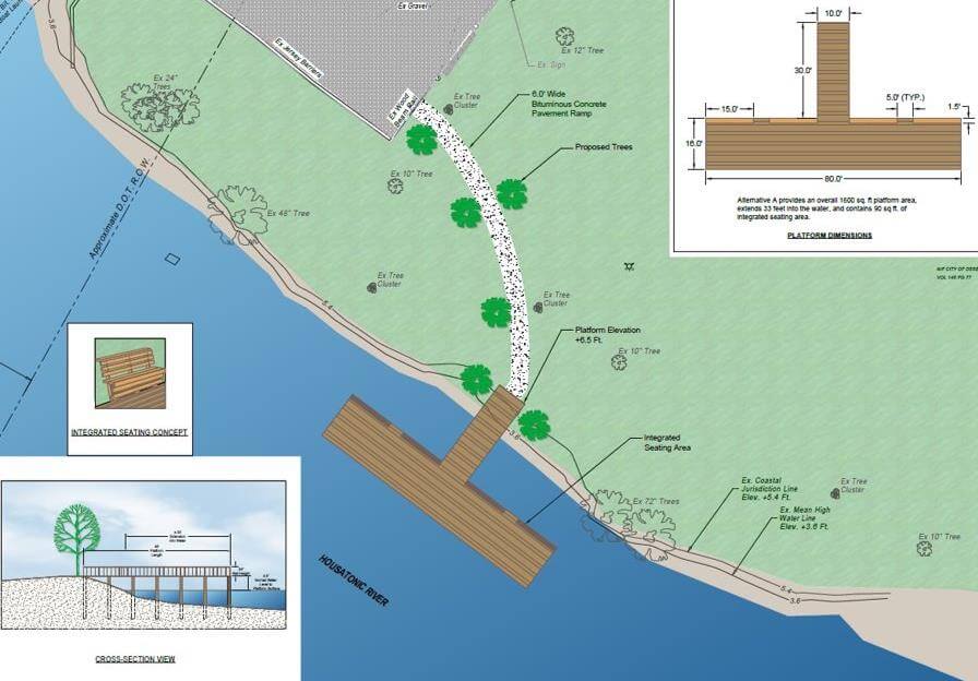
Public Information Meeting: O’Sullivan’s Island Fishing Pier Project
NVCOG held a public information meeting for the O’Sullivan’s Island Fishing Pier project on Tuesday, September 28th at 5:30 p.m. in the Aldermanic Chamber at Derby City Hall (1 Elizabeth Street). The project involves the construction of an accessible observation platform and a fishing pier extending into the Housatonic River. A recording of this meeting is available to watch on the NVCOG YouTube Channel.
For any questions concerning the project, please contact Christine O’Neill, Environmental Planner, coneill@nvcogct.gov.
NVCOG, along with its municipalities, non-profits, and businesses, worked tirelessly to get residents to participate in the 2020 Census count to show the growth the Naugatuck Valley region was experiencing. The results of the count show that not all towns and cities grew in population. However, the results did show growth in racial diversity throughout the region.
Results from the analysis NVCOG has completed on the data released by the U.S. Census Bureau for redistricting purposes can be found in a dashboard or is available for download on our data page. In the NVCOG 2020 Census Redistricting Data dashboard, view the changes in the population from 2010 to 2020 in each of our municipalities, see how diverse the region’s population was in 2020, and more. Data tables on population and self-response counts, housing, and race and ethnicity are available for download on our Data Download page.
Source: U.S. Census Bureau, 2020 Census Redistricting Data, with analysis by NVCOG GIS Department. Made with Visme
Even though NVCOG is not directly affected by redistricting, as a regional planning agency funded through state and federal sources that rely on Census data for financial distribution, we take each decennial Census seriously. Funds for our transportation projects, brownfield remediation, and environmental sustainability assessment all contain Census population counts as a factor in the funding.
Headline: Traffic Lane Shift on the Derby-Shelton Bridge (Bridge No. 01659) over the Housatonic River Which Carries Bridge Street in the Town of Shelton
The Connecticut Department of Transportation is announcing that lanes will be shifted towards the south side of the Derby-Shelton Bridge and the north-side sidewalk will be closed for Stage 1 of construction work starting on or about Wednesday, August 25, 2021.
The Connecticut Department of Transportation is announcing that the traffic flow will be reconfigured to accommodate the Stage 1 construction work. Both East and Westbound travel lanes will be reduced to 11’ wide and the northernmost sidewalk will be closed. Pedestrians and cyclists will still be able to cross the structure on the existing 10.5’ southern sidewalk. A row of precast concrete barriers will be installed to delineate the work area and reconstruction of the existing parapet will begin.
Utility work associated with the project will continue in and around the Main St., Olivia St., and 3RD St. Triangle.
The project consists of the rehabilitation and realignment of the travel ways on the existing structure. The final condition will provide a 5’ wide concrete sidewalk (north) and a 7’ wide sidewalk (south). One 11’ wide Westbound travel lane and two 11’ wide Eastbound travel lanes with 2’ shoulders for vehicles. A 3’-8” buffer zone, and a 10’ wide paved bike lane (south).
DOT Project No. 0126-0174 was awarded to Mohawk Northeast, Inc. on January 26, 2021, at a cost of $6,393,565.45 and is scheduled to be completed by November 27, 2023. This project is administered by the Office of Construction – District 3, New Haven.
Motorists can expect normal conditions except for the new fixed 11’ wide lanes. The current schedule allows for work behind the barrier both day and night if needed. Pedestrians and cyclists will be restricted to the existing southern sidewalk for passage during this stage.
The Connecticut Department of Transportation (CT DOT) is hosting three virtual public information meetings for the upcoming State Rail Plan update. This document presents strategies and programs focused on ensuring existing rail infrastructure maintenance and pursuing investments to maximize future rail services. If you’re passionate about rail service or utilize public transit, this is a terrific opportunity to learn and ask questions about this plan.
Information meetings will be conducted virtually on the following dates:
The Naugatuck Valley Council of Governments (NVCOG) social media survey is underway – we are seeking your input to better understand what content you would like to see featured on our Facebook, Twitter, and LinkedIn pages. Please take 3-4 minutes and complete our survey.
The public is invited to hear about and comment on the development of a multi-jurisdictional Natural Hazard Mitigation Plan (NHMP) for the NVCOG Region at a virtual August 4th public information meeting at 6pm. At this public meeting, the project consultants will update the public on progress and present draft recommendations. Details about the project and a link to register for the virtual meeting can be found on the project webpage at www.nvcogct.gov/hmp .
NVCOG Staff and our consultant SLR (formerly Milone and MacBroom) have been working on a multijurisdictional Regional Natural Hazard Mitigation Plan (NHMP) over the past year. The plan, funded with a grant from FEMA, will update municipal NHMPs and develop a consolidated multijurisdictional plan for the entire Naugatuck Valley planning region in compliance with FEMA standards and requirements that will serve as the approved NHMP for each NVCOG municipality. The draft 2021 NVCOG NHMP identifies natural hazards and risks, existing capabilities, and activities that can be undertaken by each community to prevent loss of life and reduce property damages associated with the identified hazards. Public safety and property loss reduction are the driving forces behind this plan.
The project team has worked with local coordinators (who served as local points of contact for the NHMP), municipal staff and stakeholders from each community to review previous plans and identify natural hazards and risks, existing capabilities, and activities that can be undertaken by a community to prevent loss of life and reduce property damages associated with the identified hazards. Information about natural hazards and potential mitigation measures was shared with the public through several municipal and public workshops and with an informational storymap. Input from municipal officials, stakeholders and the public has been incorporated into the draft report.
The draft report will be submitted first to CT DEMHS, then to FEMA for review and approval. Once approved, municipalities will adopt the plan individually, likely this fall.
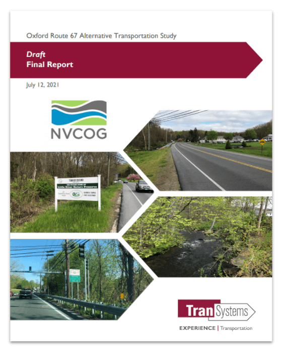
The public is invited to review and provide feedback on a Draft Oxford Route 67 Alternative Transportation Study Report. The Draft report presents the existing conditions in the corridor along with recommendations for bicycle, pedestrian, and transit improvements. Comments can be submitted until August 15th, 2021. The report and more information can be found on the project webpage at www.nvcogct.gov/oxfordroute67 .
The Oxford Main Street Alternative Transportation Study has been underway since December 2019, investigating the potential for non-motorized transportation alternatives and transit in the Route 67 corridor between Seymour and Southford. Study partners collected and analyzed information about the existing conditions in the corridor, collected input from stakeholders and the public, and investigated potential bicycle, pedestrian, and transit improvements. The focus is to improve connections and transportation options to the Seymour sidewalk network, train station and Naugatuck River Greenway Trail to the south, and the Larkin Bridle Trail to the north, as well as to all the businesses, services, green spaces, and residential areas within the corridor. The potential for transit service was also investigated, focusing on connections to services and major residential and commercial centers and to surrounding communities.
The Oxford Main Street Project Committee is overseeing the project, and it builds on previous work the committee has undertaken to improve access to the Little River and natural resources along Route 67. The goal is to provide better access to the businesses and natural resources throughout the corridor. The final report will provide a cohesive plan for the entire corridor to better enable the Town to plan, prioritize, and fund future improvements. The Naugatuck Valley Council of Governments (NVCOG) is funding the project with federal transportation planning funds. TranSystems Corporation, a planning and engineering consultant with offices in Meriden, CT is the project consultant. A final report, incorporating comments from stakeholders and the public, will be published this summer.
Oxford’s Plan of Conservation and Development prioritized creating more of a downtown feel along Route 67. Unlike many of its neighbors, Oxford does not have a typical walkable New England downtown or Main Street.
Instead, municipal and commercial areas are dispersed along with residences along State Route 67. While Route 67 fundamentally functions as Oxford’s “Main Street,” it currently has no sidewalks or safe bicycle or pedestrian access. In addition, there is currently no public transit currently operated along Route 67 providing residents an alternative transportation option. Transit options by train on Metro North and by bus on CT Transit are available only one mile from the Oxford town line, but there is currently no way for Oxford residents to safely access these services without a personal motor vehicle.
Oxford First Selectman George Temple explained that “Oxford residents have voiced support for pedestrian and bicycle access along the Little River and Route 67. This study allows us to make progress toward that goal, and to give the public a chance to help guide and contribute to future efforts”.
TranSystems Project Manager Casey Hardin said that “This is the time for area residents to provide input on the planning for this important municipal resource. The study includes recommendations to improve mobility options for bicyclists and pedestrians, as well as folks who would like options beyond their automobile”.