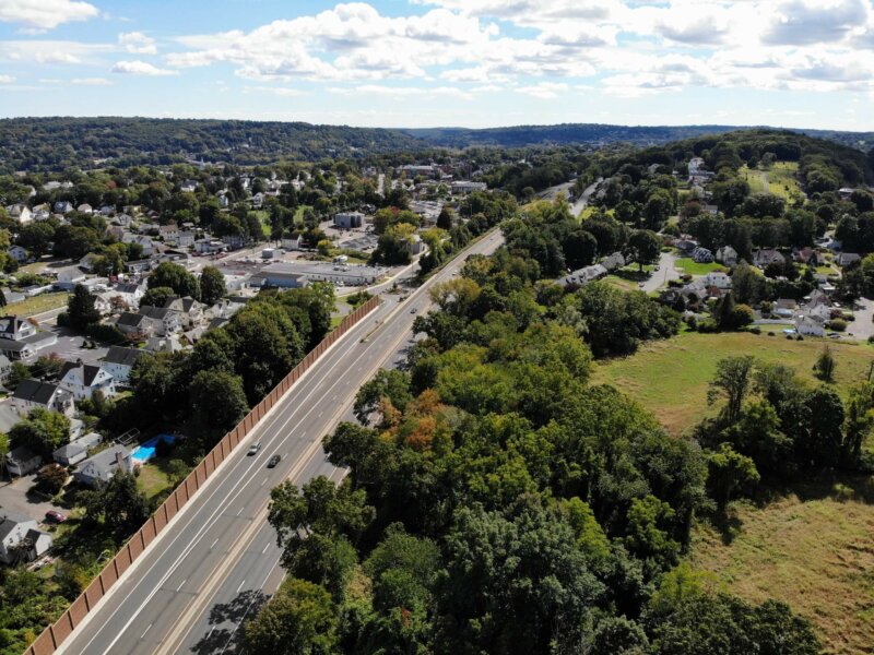
A common measure of transportation system performance is vehicle miles traveled (VMT), which looks at the total number of miles driven by personal cars across a given area. A reduction in VMT typically yields benefits for congestion, air quality, and can help reduce costs for drivers.
Active Transportation Plan
Climate Pollution Reduction Grants (CPRG)
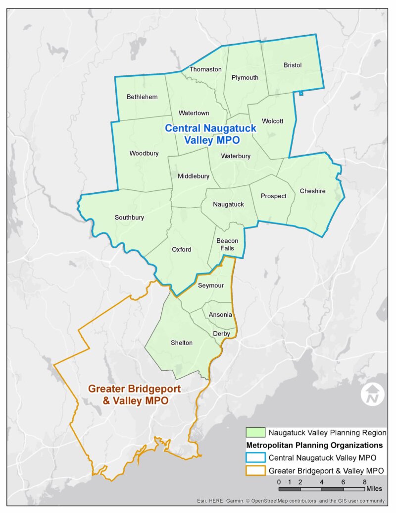
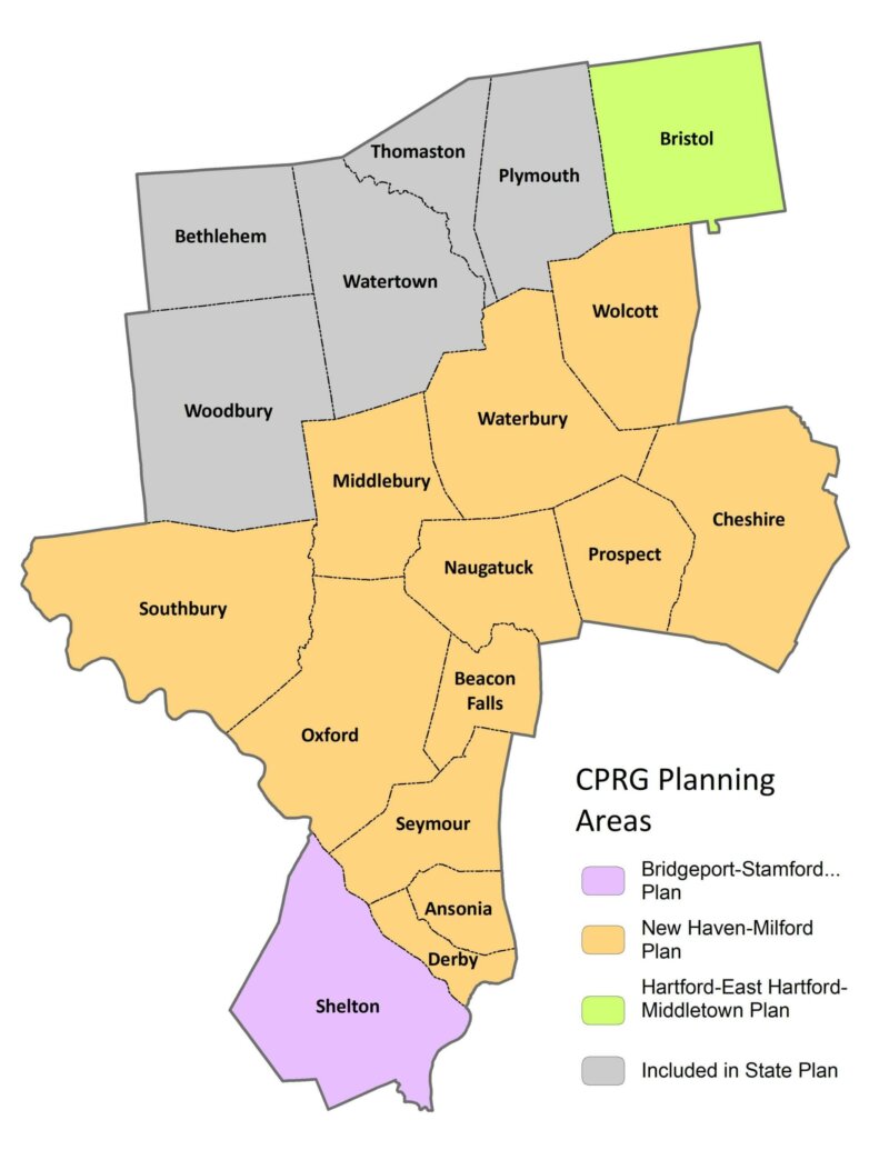
The Climate Pollution Reduction Grants (CPRG) are a five billion dollar program, created under the Inflation Reduction Act and administered through the EPA, to help state and regional governments reduce greenhouse gases. The first phase involves noncompetitive planning grants that are presumptively allocated to each state, and then to particular Metropolitan Statistical Areas (MSAs). In the case of Connecticut, the three MSAs that will receive one-million-dollar planning grants are Bridgeport-Stamford-Norwalk, New Haven-Milford, and Hartford-East Hartford-Middletown. Learn how NVCOG’s municipalities are divided below.
MTP 2050
Regional Hazard Mitigation Plan Update
The final Regional Hazard Mitigation Plan and Municipal Annexes have been posted to the NVCOG Hazard Mitigation Plan webpage. The Plan has been adopted by all 19 NVCOG Communities, and the NVCOG Board endorsed the plan on December 10, 2021. FEMA approved the plan in January, 2022.
In 2019, NVCOG received funding from the Federal Emergency Management Agency (FEMA) to conduct a multi-jurisdictional Natural Hazard Mitigation Plan (NHMP) for all 19 NVCOG municipalities.
An approved NHMP is required by FEMA to qualify a municipality for certain federal mitigation funding. NHMPs must be updated every 5 years. The purpose of this project is to update municipal NHMPs and develop a consolidated multijurisdictional plan for the entire Naugatuck Valley planning region in compliance with FEMA standards and requirements that will serve as the approved NHMP for each NVCOG municipality.

The NHMP will identify natural hazards and risks, existing capabilities, and activities that can be undertaken by a community to prevent loss of life and reduce property damages associated with the identified hazards. Public safety and property loss reduction are the driving forces behind this plan. Careful consideration will also be given to the preservation of history, culture and the natural environment of the region.
Milone & MacBroom Inc. (MMI) was selected to serve as the project consultant. MMI has extensive experience developing NHMPs in the region and across the state. NVCOG is administering the project and has prepared a detailed scope of work in collaboration with MMI. The project is expected to take 18 months and will include extensive public and stakeholder outreach and coordination with various municipal officials and departments.
Interactive Storymap:
Click on the tabs at the top of the Project Storymap and scroll through the narrative to learn about hazards impacting the region and view topical maps.
Staff Contact:
Aaron Budris
Senior Regional Planner
abudris@nvcogct.gov
COVID-19 Information
As our towns, the state, and country return to normal, NVCOG seeks to provide the best information available for the residents of our nineteen communities.
On this page, you can find links with information related to the COVID-19 pandemic for:
- Bus Transit, Commuter Rail, and Highway Updates
- Resources for Businesses
- Latest Press Releases and Executive Orders from Governor Lamont
- Local Health Districts
- Your Municipality’s COVID-19 Response web page
- Federal Departments and Agencies
NVCOG Current Status
Employees are back in the office and our office is open to the public. Public information meetings encourage in-person participation and will continue to have a virtual option for participation.
Information Sources
Below are links to trusted agencies with status updates, resources for municipalities and businesses, and the best data on how to prevent coming into contact with the virus and what to do if you do come into contact with the virus.

Click on a heading below for the resources NVCOG has compiled.
FTA Mask Travel Guidance Order and FAQ
TRB and the National Academies of Sciences, Engineering, and Medicine resources
Bristol-Burlington Health District (Bristol)
Chesprocott Health District (Cheshire, Prospect & Wolcott)
Naugatuck Valley Health District (Ansonia, Beacon Falls, Derby, Naugatuck, Seymour & Shelton)
Housatonic Valley Health District (Oxford, Southbury & Woodbury)
Torrington Area Health District (Bethlehem, Middlebury, Plymouth, Thomaston & Watertown)
Emergency Orders issued by the Governor and State Agencies
Executive Order No 700 “Protection of Public Health and Safety during COVID-19 Pandemic and Response – Procedures for Local Appointments and Elections Requiring In-Person Vote”
Governor Lamont’s Press Releases
Connecticut COVID-19 Data Tracker
Find a Test Center Near You including No-Cost COVID-19 Test Sites
Department of Public Health (DPH) resources
Department of Housing (DOH) Housing Notices and Orders regarding COVID-19
Connecticut State Department of Education Supporting Student Participation
Department of Social Services for SNAP and Child Support Services
Department of Energy and Environmental Protection (DEEP) resources for social distancing at state parks, beaches and more.
CT State Library for updates on local libraries.
Connecticut COVID-19 Charity Connection (4-CT) was launched as a non-profit that unites donors with state-wide programs that will help make an immediate impact.
Advisory Commission on Intergovernmental Relations (ACIR) news and resources
Connecticut Conference of Municipalities (CCM) resources
Connecticut Council of Small Towns (COST) news and updates
Municipal Guidance Document #1 “Suspension of In Person Open Meeting Requirements”
Municipal Guidance Document #4 “Suspension of Tax Deadlines and Collection Efforts”
Municipal Guidance Document #5 “Suspension of In-Person Voting Requirements by the Public in the Municipal Budget Process”
Municipal Guidance Document #8 Index of Executive Orders Pertinent to Municipalities
The Federal Coronavirus Aid, Relief and Economic Security Act (CARES Act) includes funds for Connecticut governments to pay costs incurred in responding to the COVID-19 pandemic. The Office of Policy and Management (OPM) has established the Municipal Coronavirus Relief Fund (CRF) Program to reimburse municipalities for such costs.
Rules on Use, Allowable Costs & Ineligible Costs and Program Overview
CT DECD – Stop the Spread in English and Spanish.
CT CBIA – Reopen Connecticut resources and materials.
CDC – Print Resources web page with information covering a variety of topics.
Watch live updates on global and national counts of COVID-19 by Johns Hopkins University
Also see state-by-state testing trends by Johns Hopkins University.
Oxford Route 67 Alternative Transportation Study
The Town of Oxford has been awarded a $3.4 million Congressionally Directed Spending grant that will pay for building a mile-long multi-use path on Route 67 that is integral to making the center of Oxford more walkable and bicycle-friendly.
Oxford was awarded the grant in December, and the project is in the design phase. The path will run from Dutton Road to Quarry Walk, a mixed-use development with stores, medical and commercial office space and 150 residential units. Plans include three pedestrian bridges to carry the path over water courses, a sidewalk between Oxford Municipal Center/ Town Hall and Academy Road along with lighting, street furniture and crosswalks.
Building a multi-use path for cyclists and walkers along Route 67 is a key component of the Oxford Route 67 Alternative Transportation Study that the town did with NVCOG and the Connecticut Department of Transportation (CTDOT). The Oxford Board of Selection endorsed the final report in February 2022.
The study investigated the potential for bicycle, pedestrian, and transit improvements along Route 67 in Oxford. The study was funded by NVCOG with federal transportation planning funds and was conducted with support by TranSystems, a planning and engineering consultant with offices in Meriden, CT. It was overseen by the Oxford Main Street Committee that was formed in 2017.
A short section of that path opened in 2021 and runs from the Little River Nature Preserve (across from Oxford Town Hall) to Dutton Road.
Existing Conditions along Route 67. Note the lack of pedestrian and bicycle accommodations.
Unlike many of its neighbors, Oxford does not have a typical walkable New England downtown or Main Street. Instead, municipal services and commercial areas are dispersed along with residences along State Route 67. Although Route 67 is fundamentally Oxford’s “Main Street,” it had no sidewalks or any safe bicycle or pedestrian access, and traffic speeds are excessive with no visual cues to alert motorists that they are driving through an area where they may encounter walkers or bicyclists. In addition, no public transit is operated along Route 67 that could provide residents an alternative transportation option. Transit options by train on Metro North and by bus on CT Transit are available only one mile from the Oxford town line, but there is currently no way for Oxford residents to safely access these services without a personal motor vehicle.
In Oxford’s 2018 Plan of Conservation and Development, the town prioritized creating more of a downtown feel along Route 67, and the Oxford Main Street Committee has been investigating streetscape improvements, sidewalks and trails within the corridor to improve non-motorized access. The study built on the committee’s prior work to develop a cohesive plan for the entire corridor to better enable the Town to plan, prioritize, and fund future improvements.
Explore Study Findings
The interactive Project Storymap presents the study and potential bicycle and pedestrian improvements to Route 67
Explore the Project Area
The interactive Project Webmap allows users to explore the project corridor in greater detail by turning on and off various data layers that are informing the study: